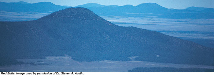
Sixteen miles from Grand Canyon's south rim, a cone-shaped butte rises like a lone sentinel 1,000 feet above the Coconino Plateau floor. Thousands of tourists rush past on Arizona Highway 64 without giving it another thought, yet this humble little hill testifies to a remarkable past.
Red Butte is composed of flat-lying shales of the Moenkopi Formation, overlain by Shinarump Conglomerate of the Chinle Formation. Continuous exposures of these two formations are not found for tens of miles around, yet they occur here. These strata sit on a foundation of flat-lying and resistant Kaibab Limestone, the rim rock for most of Grand Canyon and surface of the Coconino Plateau. A basalt (lava) flow tops the butte, protecting the softer layers below from erosion. Lava ordinarily flows downhill, so how did it get on top? Answer: it flowed onto a surface that was once 1,000 feet higher than the present Coconino Plateau! Strata of the Moenkopi, Chinle, and perhaps other formations were stripped away by erosion. Red Butte stands as the most prominent vestige of this once continuous layer.
The butte's shale slopes tell another story. These shales belong to the Moenkopi Formation, a stratum that can be traced across parts of Wyoming, Utah, Colorado, and New Mexico. Lateral equivalents of the Moenkopi may extend to Connecticut, England, Germany, Spain, and Bulgaria.1 Fossil plants, crinoids, brachiopods, gastropods, bivalves, ammonoids, nautiloids, arthropods, fish, reptiles, and labyrinthodont amphibians have been recovered from Moenkopi strata in the Grand Canyon region.2 To explain this odd assortment of terrestrial and marine taxa, and the persistence of the strata, geologists envision for western North America "a broad, continental plain that was periodically flooded by an ocean."3
A global Flood may provide the framework for a more credible depositional model. During the Flood, sediment-choked waters deposited 1,200 meters of flat-lying "Grand Canyon strata" and around 4,000 meters of Mesozoic strata (seen today atop Utah's Grand Staircase to the north, and Arizona's Black Mesa to the east). The unique vertical movements in the earth's crust during the Flood's retreat4 uplifted the region, and an enormous quantity of soft sediment was removed from its top--a volume far greater than that excavated from Grand Canyon proper.5 Red Butte is a tiny remnant from this vast erosion. When the strata gained sufficient internal strength to stand as near-vertical walls, Grand Canyon itself was incised into the plateau.
Deposition and erosion on such scales boggle the mind, yet they unquestionably took place. This humble little butte challenges geologists to think big. Perhaps this is why the Grand Canyon region fits so well with a global Flood model of earth history.6
References
- Ager, D. 1993. The Nature of the Stratigraphical Record, Third Edition. New York: John Wiley & Sons.
- Doelling, H. et al. 2000. Geology of Grand Staircase-Escalante National Monument, Utah. In Sprinkel, D.A. et al (eds.), Geology of Utah's Parks and Monuments, Utah Geological Association Publication 28. Salt Lake City: Utah Geological Association, 189-231.
- Anderson, P.B. et al. 2000. Geology of Glen Canyon National Recreation Area, Utah-Arizona. Ibid, 301-335.
- "At thy rebuke [the waters] fled….They go up by the mountains; they go down by the valleys unto the place which thou hast founded for them" (Psalm 104:7-8). The Hebrew text suggests vertical movements in the earth's crust whereby the mountains went up and the valleys went down, allowing the Flood waters to retreat.
- Mesozoic strata are conspicuously or nearly absent for an estimated 9,000 square kilometers around Grand Canyon, though they are present to thicknesses in excess of 4 kilometers in the adjacent Grand Staircase and Black Mesa regions. Erosion is estimated to have removed 36,000 cubic kilometers, dwarfing the approximately 4,000 cubic kilometers excavated from Grand Canyon (see Steven A. Austin's book Grand Canyon: Monument to Catastrophe, available at www.icr.org/store).
- A tour of the Grand Canyon region will be conducted by ICR scientists April 11 to 20, 2008.
* Mr. Hoesch is Research Assistant in Geology.
Cite this article: Hoesch, W. 2008. Red Butte: Remnant of the Flood. Acts & Facts. 37 (3): 14.