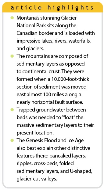
 Glacier National Park (GNP), Montana, resides at the northern tip of the USA Continental Divide, abutting against Waterton Lake National Park at the Canadian border. Established as a national park in 1910, GNP covers nearly 1,600 square miles, making it almost the size of Delaware.1 The park contains 200 lakes and over 900 miles of rivers and streams with abundant and dramatic waterfalls.1 And there are still around two dozen named glaciers in the park and several unnamed ones tucked away between the peaks.2
The mountains in GNP are themselves very striking, though they differ from those in Colorado and Wyoming because they are composed mostly of sedimentary layers, not crystalline crust. They are not as tall as the mountains in Colorado, but they make up for it in their dramatic relief. For example, Mount Cleveland rises to 10,466 feet and towers over the surface of Lake McDonald at just 3,153 feet above sea level.1 However, GNP is not just notable for its sites but also for how clearly its features proclaim the historicity of the Genesis Flood.
The Dramatic Conventional Tale
The sedimentary rocks that compose the terrain in GNP are claimed by conventional geologists to be about 1.4 billion years old.1 Known as the Belt Supergroup, these sedimentary units are unusual because “they are relatively undeformed and only slightly metamorphosed despite” their age.3 In total, they are about 18,000 feet thick in the park, and they measure over twice that outside the park’s boundaries.
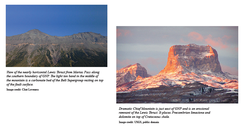
Oddly, the surface of the park is not in its original location. Instead, it is part of a two-mile-thick section of Belt rocks that were torn loose along a 300-mile suture and transported east nearly 100 miles.4 This is referred to as the Lewis Thrust. Amazingly, it moved along a nearly horizontal fault surface, parallel to bedding, placing Belt rocks on top of much younger rocks.1,4 This faulting is claimed to have occurred between 72 and 58 million years ago, more than a billion years after the Belt rocks were supposedly deposited.
But how can thick sedimentary rock layers slide so easily over the top of one another? Conventional geologists struggle with the mechanics of thrust faults because the scientists insist they are pushed by tectonic forces.5 But actual “pushing” of rocks from the rear crushes the rocks at the point of compression with no thrust development.6 And wouldn’t the Belt Supergroup rocks already be solid and impossible to fold and deform after more than a billion years?
A Better Explanation: The Global Flood
If solid rock cannot be pushed or folded, how can we explain the Lewis Thrust and the folds? The global Flood provides the answers for this and other features found at the park.
1. Only Gravity Can Move Massive Sheets of Rock
Studies have shown that high fluid pressures trapped between impermeable layers can create overpressured zones that “float” large thrust sheets down nearly flat slopes.7–9 Also, thrust sheets must move fast before the high-pressured water escapes out of the flanks of the sliding mass of sediment. Conventional explanations of thrusts moving slowly for thousands of years or more while maintaining overpressured horizons over great distances are unrealistic.10
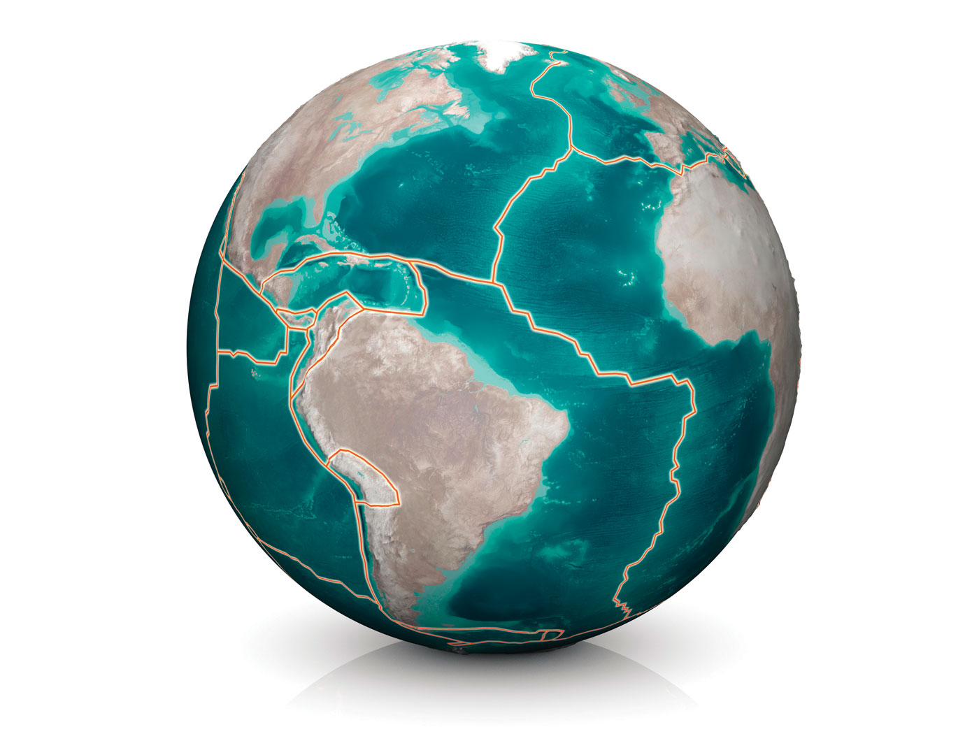
Instead, rapid thrusting, involving downslope movement of unlithified sediments by gravity, is a better mechanism for the development of large thrust sheets like the Lewis Thrust.11 And the global Flood would have provided the perfect conditions for this. The Flood provided thousands of feet of freshly deposited sediment that was compacted by the weight of each successive bed. This caused water to be squeezed out, sometimes trapping water between impermeable beds, creating overpressured zones. This is similar to how water injected between two plexiglass sheets overpressures and “floats” the layers above so they are able to slide nearly frictionless down gentle slopes. This mechanism could move thrust sheets many tens of miles. All that was needed was an initial jolt and tilt to get these “slippery,” overpressured zones to slide. The rapid uplift of the Rocky Mountains during the receding phase of the Flood likely provided the energy and tilt needed for the Lewis Thrust to quickly propagate.
2. Rapidly Deposited and Stacked Sediments
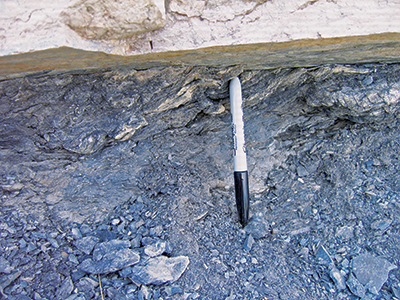
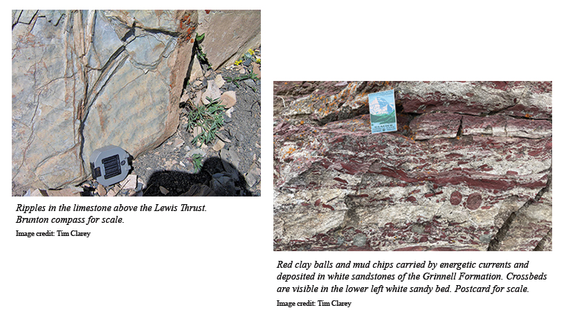
The sedimentary layers of the Belt Supergroup have many features that indicate water deposition, which the Flood would perfectly explain. First, some of the sedimentary layers are composed of limestone or dolomite, which commonly form in the ocean. Others show evidence of fast-moving water with ripples preserved in sandy beds and limestone beds, too. The Altyn Formation even contains some cross-bedded, oolitic limestone layers.4,12 Other layers have mud chips and clay balls that were ripped up and transported within their sand-rich beds.4 Ripples, ooids, and cross-beds indicate GNP’s sediments were deposited by energetic currents.
And all of the Belt Supergroup layers were deposited one on top of the other, with little evidence of erosion or time in between beds, just like a stack of pancakes. Collectively, these observations confirm continuous, high-energy water deposition as the best explanation for the vast Belt Supergroup. The Flood provided the sediment and the watery conditions.
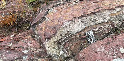
3. Folded, Freshly Deposited Sediments
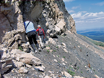
Rocks buried deep in the earth can become hot enough to fold, but they metamorphose under that heat.11 The Belt rocks are not highly metamorphosed, so we know they were never deeply buried. And yet, we observe clear evidence of folding in these rock layers—folding that supposedly happened a billion years after their deposition! The Flood again provides the best and simplest solution for these folded sediments. If these rocks were rapidly deposited during the onset of the Flood and then deformed months later as the water began to recede, then they would still have been pliable enough to fold.
4. Sculpted by the Post-Flood Ice Age
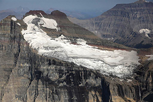
Driving through GNP, one sees much evidence of glaciation from the Ice Age. There are vast U-shaped valleys carved by moving ice and deep glacial troughs filled with lakes, like Saint Mary Lake and Lake McDonald along the Going-to-the-Sun Road.
The Flood actually created the conditions for the one and only Ice Age. It lasted about 700 years. Rapid seafloor production during the Flood year made the ocean water much hotter. This increased evaporation and caused more precipitation and snow in the mountains. Simultaneously, a peak in explosive volcanic activity at the end of the Flood produced aerosols that cooled the atmosphere.13 This allowed the snow to build up year after year until huge ice sheets filled the valleys in GNP. After the oceans cooled and the volcanic activity waned, the Ice Age abruptly ended.
Conclusion
The remarkable lakes and dramatic vistas in GNP are breathtaking. But the landscape also reveals a history of violent geological activity. Faults are exposed that rapidly moved the ground beneath the park nearly 100 miles, deforming thick Flood sediments in the process. The Flood left its signature on the rocks themselves in the flat layers, ripples, folded sediments, and other features at GNP. And post-Flood ice sheets carved out valleys and sculpted the vistas. This beautiful scenery stands as a reminder of the judgment described in Genesis.
References
- Lewis, D. et al. 2009. America’s National Parks. Lincolnwood, IL: Publications International, 110–115.
- Glacier’s Glaciers. National Park Service. Posted on nps.gov.
- Lewis et al., 481.
- Hyndman, D. W. and R. C. Thomas. 2020. Roadside Geology of Montana, 2nd ed. Missoula, MT: Mountain Press Publishing.
- Briegel, U. 2001. Rock Mechanics and the Paradox of Overthrusting Tectonics. In Paradoxes in Geology. U. Briegel and W. Xiao, eds. Amsterdam, NL: Elsevier, B.V., 231–244.
- Baumgardner, J. 2009. Personal communication.
- Hubbert, M. K. and W. W. Rubey. 1959. Role of Fluid Pressure in Mechanics of Overthrust Faulting. I. Mechanics of Fluid-Filled Porous Solids and Its Application to Overthrust Faulting. Geological Society of America Bulletin. 70 (2): 115–166.
- Guth, P. L. et al. 1982. Limitations on the Role of Pore Pressure in Gravity Gliding. Geological Society of America Bulletin. 93 (7): 606–612.
- Clarey, T. L. 2012. South Fork Fault as a Gravity Slide: Its Break-Away, Timing, and Emplacement, Northwestern Wyoming, U.S.A. Rocky Mountain Geology. 47 (1): 55–79.
- Price, R. A. 1988. The Mechanical Paradox of Large Overthrusts. Geological Society of America Bulletin. 100 (12): 1898–1908.
- Snelling, A. A. 2009. Earth’s Catastrophic Past: Geology, Creation & the Flood. Dallas, TX: Institute for Creation Research.
- Ooids are sand-sized, lime-rich balls that roll back and forth in the waves.
- Clarey, T. 2019. Subduction Was Essential for the Ice Age. Acts & Facts. 48 (3): 9.
Stage image: Logan Pass, Glacier National Park, Montana
Dr. Clarey is the director of research at the Institute for Creation Research and earned his Ph.D. in geology from Western Michigan University.