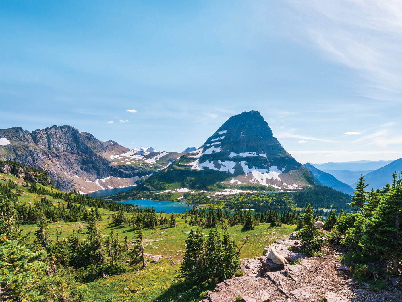
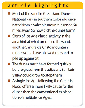
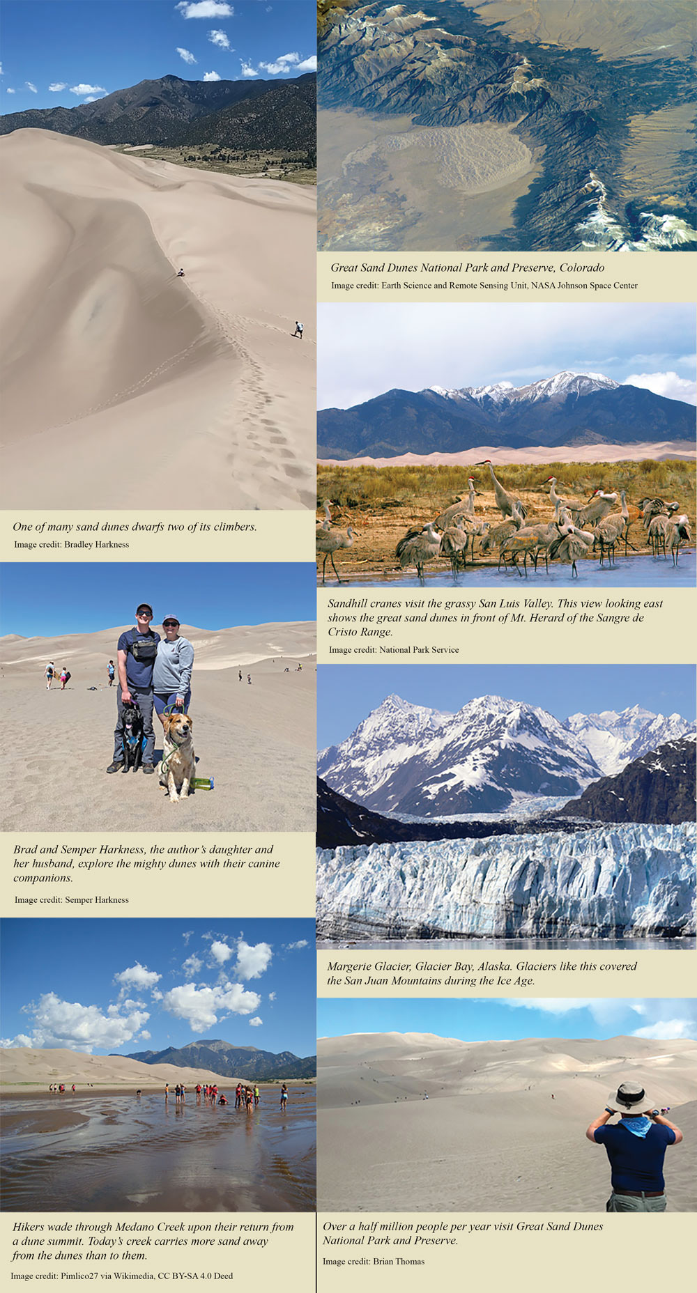
 The tallest sand dunes in North America are found in Great Sand Dunes National Park and Preserve, located on the eastern edge of the San Luis Valley in southern Colorado. The largest of the dunes reaches 700 feet above the valley floor. Visitors to the park have to slog up sand for about an hour just to reach its top!
A satellite’s-eye view shows the dunes nestled in a bend of the Sangre de Cristo mountain range. Signage at the park attributes the dunes to the unique wind patterns that cross the San Luis Valley, which extends westward from the dunes around 50 miles until it reaches the San Juan Mountains.1 But surely there is more to this story. What built these mountains of sand?
What It Takes to Make a Dune
A group of Colorado-based geologists offered three requisites for dune formation in a study on the origin of the Great Sand Dunes.2
- An adequate supply of dry, loose sand—the rarest requisite
- A means to transport the sand, such as wind
- An obstacle (e.g., a mountain range) for the dune to form against so the sand doesn’t keep drifting
The same geologists also listed common factors that keep sand from forming dunes. These include sand mixing with clay particles or any liquid water, both of which hold sand grains down. Rocks can hinder the sand’s progression along the ground, as can roots and leaves from even sparse vegetation. Today, the San Luis Valley has plenty of grass and marshes that keep sand from going too far. The conditions, then, must have been different in the past for the sand to have formed these giant dunes.
Where Did All This Sand Come From?
Geologists analyzed sand grains from the dunes to find the sand’s sources. It turns out that about 30% came from the nearby Sangre de Cristo Range.2 This range comprises an uplifted block, called a horst, of crustal granite and gneiss. About 70% of the sand came from the faraway San Juan Mountains, which are relatively younger and entirely volcanic. Enormous calderas among these mountains mark where super-volcanoes erupted.3
Today’s slow processes and winds do not grind rock into sand, transport it 50 miles west, and build new dunes with it. Thus, both conventional and catastrophist geologists lean on Ice Age conditions to explain the dunes’ origins.
In the past, glaciers scoured some mountain valleys into U-shaped profiles called troughs. Moraines, piles of rock debris that vary from clay and sand to boulders, mark the edges of the glaciers that once bulldozed nearby mountain slopes. Evidence of these indicate that ice once pressed down the San Juan Mountains, which hold the headwaters of the Rio Grande, during the Ice Age. Indeed, “the main Rio Grande glacier was about 60 km [37 mi] long and covered nearly 1000 km2 [386 mi2].”2 The connected glaciers together formed the western San Juan ice cap.4 Melting glaciers ground rock into sand and spread that sand across the valley with help from accelerated winds.
Putting the Pieces Together
So, what pieces do we have for the dune formation puzzle? A vast quantity of sand derived mostly from the volcanic San Juan Mountains via glacial activity, the sand’s transportation 50 miles across the San Luis Valley, a backstop mountain range where the sand accumulated, and dunes forming quickly before grass could grow to stop them.
What historical happening can fit these pieces together? Creationists recognize that the world-destroying forces at play during Noah’s Flood pushed the Sangre de Cristo Range mountains upward as floodwaters receded.5 Soon after, magmas beneath the earth blasted through the crust along the Rockies.6 One volcano after another, including a few supervolcanoes, erupted continuously during and after the Flood.
This contributed to the start of the Ice Age, which needed brief timespans between volcanic eruptions for them to repeatedly pump enough aerosols into the sky to block sunlight and keep ice from melting in the summertime.7 Conventional geologists don’t believe the Flood is historical and insist that long timespans separated past volcanic eruptions, so short timespans don’t fit their way of thinking. However, they do agree that because of an Ice Age, glaciers formed in the mountains and grew as ice thickened over time. Eventually, eruptions slowed and ice melted.
As the Ice Age ended, glacial meltwater carried and deposited ground-up rock material in a huge fan of sand across the broad San Luis Valley. Strong gales like glacial winds (a type of katabatic wind) blew sand far to the east until it piled against the Sangre de Cristos.8 Critically, this must have happened after the water table dropped beneath the sand’s capillary fringe level for the topmost sand to be dry but before vegetation had time to cap the sand.9 Soon grass grew, halting dune growth. Ever since, prevailing winds that blow east and intermittent winds that blow west over a saddle in the Sangre de Cristos have kept the dunes piled high.
This explanation for the Great Sand Dunes requires many precise events to have occurred. Because conventional scientists insist on multiple Ice Ages, they maintain these unlikely events happened multiple times to form the dunes. Each time one of their many Ice Ages occurred, glacial outwash transported sand for miles, the valley’s water table sunk low enough for that sand to dry, and strong winds blew—all before grass could grow.
All of this happening once at the end of a single Ice Age is more likely than it happening exactly that way dozens of times. Meanwhile, conventional scientists still struggle to explain how even one Ice Age can happen. The Great Sand Dunes therefore serve as awe-inspiring monuments to a single, recent Ice Age.
References
- Madole, R. 2020. Pleistocene Glaciations and the Evolution of the Great Sand Dunes. In The Geology, Ecology, and Human History of the San Luis Valley. J. M. Beeton, C. N. Saenz, and B. J. Waddell, eds. Denver, CO: University Press of Colorado, 87.
- Madole, R. F. et al. 2008. On the origin and age of the Great Sand Dunes, Colorado. Geomorphology. 99 (1–4): 99–119.
- Supervolcanoes generated 1,000 km3 of material. See the United States Geological Survey fact sheet titled “What is a supervolcano? What is a supereruption?” Posted on usgs.gov, accessed December 18, 2023.
- Beeton, J. M. and G. G. Johnson. 2020. Geomorphology and Climate Change in the San Luis Valley. In The Geology, Ecology, and Human History of the San Luis Valley. J. M. Beeton, C. N. Saenz, and B. J. Waddell, eds. Denver, CO: University Press of Colorado, 65.
- The recency of the Flood explains why erosion has not yet erased this ancient mountain range.
- The unique conditions following the Flood help account for the supervolcanoes that happened all around the Pacific and elsewhere at the time but are no longer seen today.
- You can learn how the Flood supplied the four key factors needed for an Ice Age in Hebert, J. 2018. The Bible Best Explains the Ice Age. Acts & Facts. 47 (11): 10-13.
- In the single, recent Ice Age model, cooling oceans fueled high winds at the end of the Ice Age. See Oard, M. 2004. Frozen in Time. 2004. Green Forest, AR: Master Books, 160.
- Water ascends between sand grains above the water table by about four inches, depending on grain size.
* Dr. Thomas is Research Scientist at the Institute for Creation Research and earned his Ph.D. in paleobiochemistry from the University of Liverpool.

.jpg)