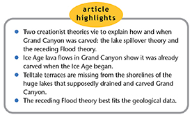
 There has been considerable debate among scientists over the origin of Grand Canyon. We all agree it was formed by the removal of some 1,000 cubic miles of sediment and rock, leaving a canyon 277 miles long and four to eighteen miles wide with a depth of over 6,000 feet in some locations. Many secular geologists claim the canyon formed in the last six million years or so by slow erosion.1 Creation geologists believe the evidence supports rapid erosion from vast amounts of water over a short time frame—carving Grand Canyon just several thousand years ago.
But even creation geologists differ in their interpretation of the source of water that carved the canyon. Was the water from temporarily dammed lakes that spilled out catastrophically a few hundred years after the Flood, or was it carved a bit earlier by the receding water of the Flood itself?
Problems with the Lake Spillover Hypothesis
The lake spillover hypothesis became popular in the 1990s when creation scientists used surface topography to construct large hypothetical lakes just to the east of present-day Grand Canyon (Figure 1).2,3 This view holds that Grand Canyon was formed in the post-Flood period by the sudden breaching of two presumably dammed lakes: Hopi Lake and Grand Lake (alternatively called Canyonlands Lake). Theory proponents believe they formed a few hundred years after the Flood during the Ice Age or shortly thereafter. The lakes potentially could have held over 3,000 cubic miles of water, roughly equivalent to three times the volume in Lake Michigan.1 The explanation for the breach varies, but advocates claim a catastrophic water release, or spillover, carved Grand Canyon.
In previous works, I have pointed out the lack of physical evidence for these hypothetical lakes.4,5 There is virtually no support for the northernmost lake, Canyonlands Lake, and there are no wave-cut lake terraces or strand lines, as would be expected, around the rim of either of these supposed lakes. In contrast, we see clear, wave-cut terraces around the edges of all other large Ice Age lakes, including Lake Bonneville, which has largely evaporated to become Great Salt Lake today. Lake Bonneville’s terraces and strand lines are clearly seen along the front of the Wasatch Range and elsewhere, marking its former extent.4,5
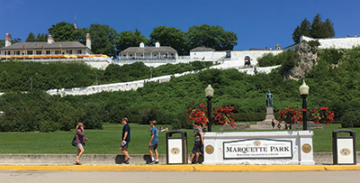
We also see evidence of former Ice Age lake levels marked by clear, wave-cut terraces around the Great Lakes region. There are two such strand lines on Mackinac Island alone—the Nipissing and Algonquin terraces—representing fluctuating water levels during the Ice Age (Figure 2).
John Wyatt, who spent about 40 years in Africa working on hydroelectric projects, had this to say when asked if he observed the formation of wave-cut lake terraces on reservoirs and how long they took to form:
Yes, I have frequently seen wave-cut ledges on lakes and reservoirs. A huge number of factors are involved including prevailing winds, storms, geology and long-term/changing water levels, but I have seen them begin to appear both within a few days and after much longer periods of relative stability.6
The fact remains that there are no wave-cut terraces found around the rim of either Canyonlands Lake or Hopi Lake. However, there are some sedimentary deposits that have been interpreted as water-deposited lake sediments in parts of the hypothetical Hopi Lake, known as the Bidahochi Formation.4 But this unit has been found to be too old to be an Ice Age lake deposit and is more likely a remnant from the receding phase of the Flood.1,4
Learning from Recent Dam Catastrophes
I recently returned from Michigan where I visited the site of two recent dam failures that catastrophically drained both Wixom and Sanford Lakes. These lakes were created by dams on the Tittabawassee River. The upstream Wixom Lake had a normal capacity of about 36,000 acre-feet (1.55 billion cubic feet), a maximum depth of 40 feet, and about 84 miles of shoreline.7 The downstream Sanford Lake had a lake volume of 13,900 acre-feet (600 million cubic feet), a maximum depth of 26 feet, and a shoreline of about 35 miles.8 Both the Edenville dam on Wixom Lake and the Sanford dam were completed in 1925, creating two reservoirs that existed for nearly 100 years.9,10
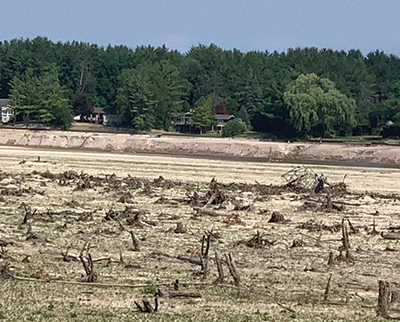
After a heavy spring rainstorm dumped four to seven inches across the region, the collapse of the Edenville dam sent the water of Wixom Lake rushing toward Sanford Lake, immediately downstream. This massive volume of water (21.5 billion gallons) emptied in one hour at rates of 60,000 cubic feet per second and overwhelmed the Sanford dam, pouring the volume of both reservoirs into the Tittabawassee River on May 19–20, 2020. This flooded downstream cities like Midland, Michigan, forcing 10,000 people to flee their homes.11 Although no canyon was carved by this disaster, the emptied lakes revealed some secrets. As I examined the former Sanford Lake, I noticed a well-defined wave-cut step or terrace around the edge of the former lakebed (Figure 3). The reservoirs had indeed carved a lake terrace around the rim of the lake marking the stable water level prior to its rapid drainage.
Lake terraces and lake strand lines nearly always form if a large lake exists for any significant amount of time. But the advocates of the spillover hypothesis offer no explanation for the lack of lake terraces around their proposed lakes. If these lakes really existed, there should be observable terraces. Merely drawing a line along a topographic contour doesn’t create real bodies of water.
Ice Age Lava Flows Drain the Spillover Hypothesis
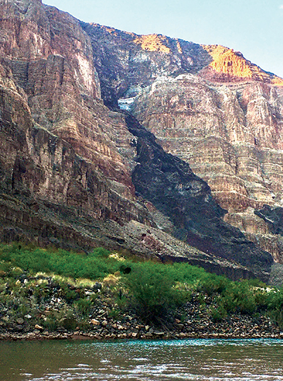
Another major and nearly insurmountable problem with the spillover hypothesis involves timing. During the Ice Age, there were over 150 lava flows that poured down the walls of Grand Canyon from volcanism on Uinkaret Plateau.12 (See Figure 4.) These flows demonstrate that the canyon already existed either prior to the Ice Age or very early in the Ice Age because the lavas poured down over the carved canyon walls. At a minimum, the 150 lava flows severely limit the time available for the lakes to build up the necessary 3,000 cubic miles of water needed to carve the vast canyon. There is simply not enough time between the canyon being carved, the lava flows pouring down the sides, and the lakes building up enough water to make the spillover hypothesis viable. When did the presumed Hopi and Canyonlands Lakes fill with water if not during the Ice Age, when the lava flows dictate the canyon was already in existence? These lava flows demonstrate the near impossibility of a spillover formation for Grand Canyon. The child cannot be born before the parent.
Receding Flood Carved Grand Canyon and Others
Water follows the easiest path. Receding floodwater would naturally have followed the cracks and fractures in the freshly deposited and uplifted Flood sediments of the Colorado Plateau. The water draining off the Colorado Plateau would have flowed westerly toward the Pacific Ocean. Rapid uplift and surface drainage of receding floodwater provide both the path and the necessary volume of water to quickly carve out Grand Canyon. And this process would have concluded prior to the Ice Age, eliminating any timing conflicts with the canyon formation and the later lava flows originating on the Uinkaret Plateau. No hypothetical lakes are necessary as a water source in this explanation.
In addition, two other large canyons that formed in Greenland and Antarctica are bigger or similar in size to Grand Canyon. The Greenland canyon is as deep as Grand Canyon and 450 miles in length.13 It was not formed by the scouring of the current ice sheet but is older, going back to the time of Pliocene deposition just before the Ice Age began and formed late in the receding phase of the Flood.13 Recently discovered Denman Canyon in Antarctica is 62 miles long and actually twice as deep as Grand Canyon.14 It also appears to have had its beginnings prior to the Ice Age during the receding phase of the Flood.
In the United States, other large canyons also formed during the receding phase of the Flood, such as Texas’ Palo Duro Canyon. But it’s not as deep as Grand Canyon and formed from runoff that flowed eastward away from the uplifted Rocky Mountains late in the Flood.15 Massive canyons on multiple continents are a global phenomenon. Common global features require a common global explanation, and the receding phase of the Flood provides the perfect conditions to carve large canyons. The sheer volume of water that had to drain off the continents provides the water necessary to rapidly carve these canyons in a matter of weeks or a few months.
The N-Q Flood Boundary Eliminates Issues
Many earlier researchers had their hands tied because they believed the Flood ended at the end of the Cretaceous system (K-Pg, or Cretaceous-Paleogene). In this view, there was no large source of water available to carve Grand Canyon by the time of the Ice Age. These scientists had to envision the hypothetical lakes to provide sufficient water to carve the canyon.
However, if the boundary for the end of the Flood is correctly moved up to the top of the Pliocene (N-Q, or Neogene-Quaternary), as we demonstrated in a recent article,16 there is no lack of water and no timing problem. Grand Canyon was carved prior to the Ice Age during the receding phase of the Flood (upper Neogene period). The later lava flows simply poured over the freshly carved canyon walls as we observe today. We can safely conclude that the spillover hypothesis is the wrong explanation for Grand Canyon. There never were any large lakes east of Grand Canyon during the Ice Age, nor were they necessary to carve the canyon. The receding floodwater had sufficient volume to do the job.
References
- Helble, T. and C. Hill. 2016. Carving of the Grand Canyon: A Lot of Time and a Little Water, a Lot of Water and a Little Time (or Something Else?). In The Grand Canyon, Monument to an Ancient Earth: Can Noah’s Flood Explain the Grand Canyon? C. Hill et al, eds. Grand Rapids, MI: Kregel Publications, 163-172.
- Austin, S. A. 1994. How Was Grand Canyon Eroded? In Grand Canyon: Monument to Catastrophe. Santee, CA: Institute for Creation Research, 83-110.
- Brown, W. 2015. In the Beginning: Compelling Evidence for Creation and the Flood, 9th ed. Phoenix, AZ: Center for Scientific Creation.
- Clarey, T. 2018. Grand Canyon Carved by Flood Runoff. Acts & Facts. 47 (12): 10-13.
- Clarey, T. 2020. Carved in Stone: Geological Evidence of the Worldwide Flood. Dallas, TX: Institute for Creation Research.
- Wyatt, J. Personal communication. 2020.
- Wixom Lake. Wikipedia. Posted on wikipedia.org, last modified June 20, 2020.
- Sanford Lake. Wikipedia. Posted on wikipedia.org, last modified June 17, 2020.
- Edenville Dam. Wikipedia. Posted on wikipedia.org, last modified May 31, 2020.
- Sanford Centennial Museum. Sanford Historical Society. Posted on sanfordhist.org, accessed July 23, 2020.
- At 21.5 billion gallons, Wixom Lake is twice as big as Oakland County’s largest lake—it emptied in one hour. Fox 2 Detroit. Posted on Fox2detroit.com May 21, 2020, accessed July 23, 2020.
- Beus, S. S. and M. Morales, eds. 1990. Grand Canyon Geology. New York: Oxford University Press, 386-387.
- Keisling, B. A. et al. 2020. Pliocene–Pleistocene megafloods as a mechanism for Greenlandic megacanyon formation. Geology. 48 (7): 737-741.
- Amos. J. Denman Glacier: Deepest point on land found in Antarctica. BBC News. Posted on BBC.com December 12, 2019, accessed March 27, 2020.
- Clarey, T. 2018. Palo Duro Canyon Rocks Showcase Genesis Flood. Acts & Facts. 47 (7): 10.
- Clarey, T. 2020. Compelling Evidence for an Upper Cenozoic Flood Boundary. Acts & Facts. 49 (5): 9.
* Dr. Clarey is Research Associate at the Institute for Creation Research and earned his Ph.D. in geology from Western Michigan University.