



 Numerous authors have speculated on the extent of the early floodwaters and on when the Flood peaked. Many questions remain unanswered. For example, did the Flood cover the continents early in the Flood year, recede, and then rise again? Did the waters rise once and peak around Day 150? Or was it some combination? Our latest research provides some answers.1
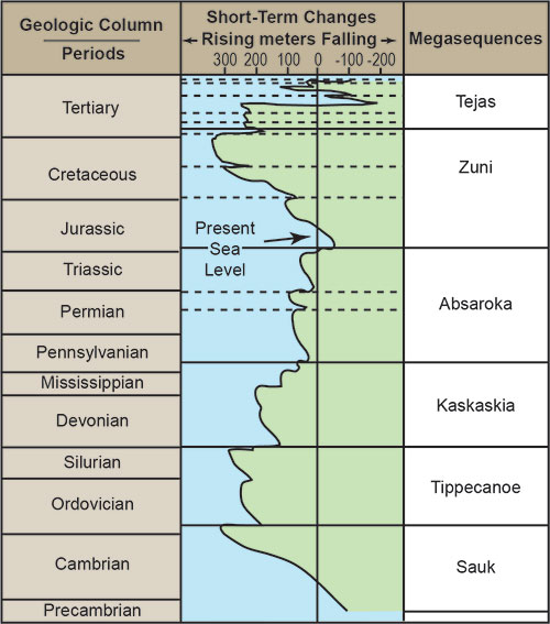
Figure 1 shows the megasequences defined by geologist L. L. Sloss and the secular sea level curve during the time of their deposition.2 Although Sloss initially defined his megasequences across only the interior of North America, oil industry geologists quickly extended these boundaries to the offshore regions and adjacent continents using oil-well logs and seismic data.3 Secular geologists claimed global sea level reached an extreme high during the Sauk Megasequence (Figure 1).
Many creation geologists think the Sauk Megasequence represents early Flood deposits. In many places, the base of this layer is also known as the Great Unconformity.4 The bottom layer of the Sauk Megasequence is also coincident with the so-called Cambrian explosion in which marine fossils representing many animal phyla suddenly appear in the rock record.
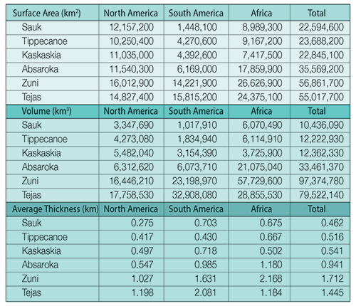
ICR’s research is one of the first attempts to map the true extent of the sedimentary rocks across the continents and to test the validity of the published secular sea level curve model (Figure 1).1 The area covered by the Sauk Megasequence across North America is over 12 million km2 (Table 1 and Figure 2A). Sauk deposits are several kilometers thick along the east and west coasts of the North American continent and yet are very thin (only a few tens of meters) to nonexistent across the central part of the continental United States. They average only about 275 meters deep across the North American continent where present (Table 1).
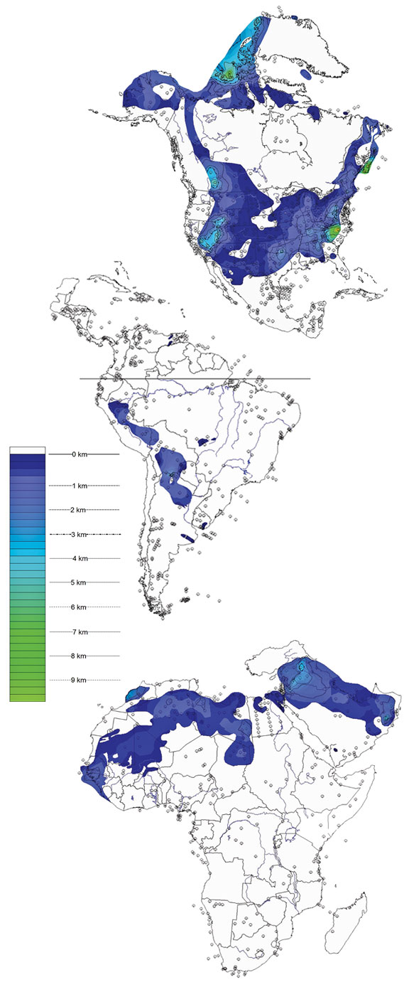

In stark contrast to North America, the sedimentary rocks of the Sauk Megasequence show very little coverage across South America (Figure 2B) and Africa (Figure 2C). The South American coverage is about 1.45 million km2 and across Africa is just under 9 million km2 (Table 1). Only the northernmost part of Africa and the west-central portion of South America show any Sauk sediments. Finally, the total volume of sediment deposited during the Sauk Megasequence represents one of the minimal amounts for each of the three continents compared to later megasequences (Table 1).
The rock data suggest the floodwaters rose progressively as described in Genesis 7 with only limited flooding during the Sauk event. The Sauk Megasequence was only the violent beginning of the Flood, creating the Great Unconformity at its base and encasing prolific numbers of the hard-shelled marine fossils that define the Cambrian explosion. The peak height of the floodwaters seems to have occurred later, possibly around Day 150 during the Zuni Megasequence, as that is when the coverage and volume of sediment also peak on most of the continents (Table 1).
After reviewing the vast oil-well data, we concluded that the published secular global sea level curve is inaccurate in an absolute sense and should only be considered relative at best. In addition, the amount of pre-Flood dry land inundated during Sauk deposition seems to have also been limited. As we suggested in 2015, the Sauk probably represents the effects of tsumani-like waves that transported sediment across pre-Flood shallow seas and not across land masses.5,6 This could also possibly explain why so few, if any, terrestrial animals and plants are found as fossils in Sauk Megasequence rocks.
References
- Clarey, T. L. and D. J. Werner. 2017. The Sedimentary Record Demonstrates Minimal Flooding of the Continents During Sauk Deposition. Answers Research Journal. 10: 271-283.
- Sloss, L. L. 1963. Sequences in the Cratonic Interior of North America. Geological Society of America Bulletin. 74 (2): 93-114.
- Haq, B. U., J. Hardenbol, and P. R. Vail. 1988. Mesozoic and Cenozoic chronostratigraphy and cycles of sea-level change. In Sea-Level Changes: An Integrated Approach. Tulsa, OK: Society of Economic Paleontologists and Mineralogists, 71-108.
- Peters, S. E. and R. R. Gaines. 2012. Formation of the ‘Great Unconformity’ as a trigger for the Cambrian explosion. Nature. 484: 363-366.
- Clarey, T. L. 2015. Examining the floating forest hypothesis: a geological perspective. Journal of Creation. 29 (3): 50-55.
- Clarey, T. 2015. Dinosaur Fossils in Late-Flood Rocks. Acts & Facts. 44 (2): 16.
- Sloss, Sequences in the Cratonic Interior of North America; Vail, P. R. and R. M. Mitchum Jr. 1979. Global cycles of relative changes of sea level from seismic stratigraphy. American Association of Petroleum Geologists Memoir 29, 469-472.
* Dr. Clarey is Research Associate at the Institute for Creation Research and earned his Ph.D. in geology from Western Michigan University.