SUBMARINE FLOW AND SLIDE DEPOSITS IN THE KINGSTON PEAK FORMATION, KINGSTON RANGE, MOJAVE DESERT, CALIFORNIA: EVIDENCE FOR CATASTROPHIC INITIATION OF NOAH'S FLOOD
| ROGER SIGLER 19114 TREE TOAD DRIVE KATY, TX 77449 |
VAN WINGERDEN P.O. BOX 902 LAKE ISABELLA, CA 93240 |
Presented at the Fourth International Conference on Creationism
Pittsburgh, PA, August 3-8, 1998
Copyright 1998 by Creation Science Fellowship, Inc.
Pittsburgh, PA USA - All Rights Reserved
Pittsburgh, PA, August 3-8, 1998
Copyright 1998 by Creation Science Fellowship, Inc.
Pittsburgh, PA USA - All Rights Reserved
KEYWORDS:
Breccia, Megabreccia, Megaclast, Olistolith, Debrite, Olistostrome, Mojave Desert, Unconformity, Earthquake, Faulting, Submarine Landslide, Debris Flow, Diamictite, Sturzstrom, Precambrian, Proterozoic, Pre-Flood/Flood Boundary, Plate Tectonics, California
ABSTRACT
The case for a glacial origin for the upper Proterozoic Kingston Peak Formation is weak. Stratigraphic correlations and rock descriptions suggest a marine depositional environment for the entire formation. The Lower Sandstone Unit of the Kingston Peak Formation is best interpreted as an Antediluvian inner shelf deposit. It is underlain by other widespread shelf deposits, the Beck Spring Dolomite followed by the Crystal Spring Formation which rests on granitic gneiss. Overlying these deposits are thick accumulations of puddingstones (called diamictite by many) interpreted as debrites. These, in turn, are overlain by rhythmically laid breccias and megabreccias interpreted as suspension-sturzstrom deposits. The debrites and sturzstrom are comprised of debris derived mainly from the underlying Beck Spring Dolomite and Crystal Spring Formation. Large-scale catastrophic plate tectonics associated with the subduction zone to the west caused the Antediluvian sea floor to collapse. Debris flows moving at the rate of 15-30 m/s were instantly generated at the onset of massive local faulting associated with the event. A displacement of perhaps 950 m or more in some areas along the giant fault scarp converted the shelf to a 600 slope environment. This activity spawned seismic sea waves. Sheet flows of fluidized rock masses fell over the cataract and flowed across the basin at 50-100 m/s. In the deeper areas large scale slumping occurred as huge megaclasts or olistoliths hundreds of meters long slid downslope within a succession of high concentration turbidites. These catastrophic coarse clastic deposits of the middle and upper Kingston Peak Formation at the Kingston Range directly overly and crosscut into the Crystal Spring Formation and crystalline basement at nearby mountain ranges. This unconformity of extreme magnitude may correlate with the Great Unconformity and mark the base of the Sauk megasequence. After these initial Flood sediments were deposited widespread marine sediments, beginning with the Noonday Dolomite began to be deposited as the oceans inundated the continents.
INTRODUCTION
The upper Proterozoic "Pahrump Group" is divided (from bottom to top) into the Crystal Spring Formation, Beck Spring Dolomite, and Kingston Peak Formation; the Crystal Spring rests on a crystalline basement of granitic gneiss and the Noonday Dolomite overlies the Kingston Peak Formation [5,16,55]. The Kingston Peak ranges in thickness from zero to more than 3 km over a distance of less than 4 km [46]. It contains rhythmites (a succession of repetitious sedimentary beds) with predominant graded beds [43]; turbidites, conglomerate, breccia and megabreccia [47]; gigantic clasts up to about 1.5 km in length [23,42,46]; boulders associated with deep water turbidites and diamictite layers [55]; and limestone [18]. "Diamictite" is a nonsorted or poorly sorted, noncalcareous, terrigenous sedimentary rock with a wide range of particle sizes [4]. Breccias are called megabreccia when some of the clasts reach 1.0 meter in length or greater. Blocks and slabs occur within sheets of monomictic (one rock type) megabreccia totaling approximately 1.5 km in thickness at some locations [46, 47].
Over the years several general studies have been made of the Kingston Peak Formation and correlative strata on a regional and even global scale. In western North America the Kingston Peak Formation apparently correlates with other formations from Mexico northward through the western United States and Canada up to at least Alaska [41], and may correlate with the Sixtymile Formation of the Grand Canyon Chuar Group [1]. Correlative strata in Utah, Idaho [8,42], and Washington state are called the "diamictite and volcanic sequence" [42, p.2]. It is the only known unit "in the Precambrian and Paleozoic sequence that contains diamictite, and in most of those same areas it is the only unit that contains abundant volcanic rocks" [42, p.4]. Upper Proterozoic "diamictites" have also been located from at least 100 other formations located in at least 15 countries including other parts of the United States [14].
If the Kingston Peak Formation does correlate with the other formations on such an extensive scale then a similar depositional environment is implied. Many uniformitarian geologists [e.g. 23,24,45,50] hypothesize that the Kingston Peak Formation was deposited as a result of large scale glacial activity over millions of years even though detailed studies have not been made [sscking@ptd.net >50, 55]. Some call the diamictite by the genetic name "tillite" [e.g. 50,51], the lithified equivalent of glacial till [4]. Creationists [e.g. 1,2,28] recognize the implications of these deposits and [1,2] believe that detailed field studies in this area could distinguish which rocks existed prior to Noah's Flood from those formed at the start of the Deluge. The purpose of this paper is to present the data gathered in the field which evidences some of the initial submarine landslide Flood deposits in this area; the probable seismic activity associated with the deposits; and a proposed rate of sedimentation.
PAST RESEARCH AND SPECULATIONS OF THE DEPOSITIONAL ENVIRONMENT
Suggestions for the depositional environment of the Kingston Peak Formation at various locations include fanglomerates or alluvial fans [16]; glacial processes [23,24,25,45,50], and submarine landslides or debris flows [1,33,50,53]; or a combination of these depositional environments as climatic changes occurred over an assumed 50-150 million years [14]. Hewitt [16] believed the middle coarse conglomerate portion of the Kingston Peak Formation at the Kingston Range, comprised largely of quartzite and dolomite clasts, represents a fanglomerate which stratigraphically lies between upper and lower Kingston Peak tillites. Although no one has systematically critiqued the fanglomerate interpretation, most modern authors [1,5,18,23,24,25,33,40,41,43,45,46,48,49,53,56] accept and document evidences for rapid deposition in a submarine environment. Sedimentary structures of the formation, commonly observed in turbidites, include flame structures, scour and fill features, load casts, flute casts, convolute lamination and slump structures [45]. Furthermore, thin sandstone beds, within Kingston Peak limestones at the Panamint Range (80 km west of the Kingston Range), are similar to many other storm beds or tempestites from the geologic record..."they generally reflect offshore sediment transport by storm-surge currents and waves" [50, p. 822], and thicker sandstone beds show a low undulating lamination like the hurricane deposit known as hummocky cross-stratification (HCS). The general "shelf context" of the Kingston Peak Formation in the Black Mountains (50 km northwest of the Kingston Range), together with the local evidence for current reversals and HCS, "suggests that a storm origin is most likely, with deposition taking place close, to below storm-wave base, mid to outer shelf' [50]. Thick lenses of pillow basalt also occur within the diamictites in the Panamint Range [25].
The Kingston Peak Formation is "of doubtful glacigenic origin" [14, p. 283]. The general appearance of sporadic and isolated pebbles within an abundance of sandy and limy matrix is the only reason given why the upper and lower deposits were called "tillites" [16]. However, using the word "tillite" as a descriptor term unjustly leads to the conclusion that pebbly beds in the geologic record were deposited as an "accumulation of glacial till" [33]. Moreover, matrix supported isolated boulders within abundant matrix are also formed by subaqueous debris flows [28]. Other specific evidences usually cited for a glacial environment are striated and faceted stones [25,33,43,45]; dropstones, isolated sand and gravel clots, striated pavement [43]; and homogeneity, thickness and lateral extent of diamictite units [25]. In the Kingston Range, features indicative of a glacial origin have not been found [53]. Furthermore, "none" of the pebbles and cobbles observed are "distinctly faceted or showed striae" [16]. But even if some are, striations and facets can also be formed by streams or faulting [4,33]. Miller [25] located isolated boulders called dropstones, which she believes were dropped by icebergs. Indeed, others [24,45,50,55] also speculate that many of the deposits in the Kingston Peak Formation are 'Iglaciomarine", the view that the sediments were derived by glaciers and redeposited in a marine environment by ice rafting, debris flows, and turbidity currents during ice advances [25,45]. This claim also hypothesizes that during retreat, glacial meltwaters supplied the sediments for the rapid formation of rhythmites [40], and the widespread laminated limestone records glacial retreat and marine transgression [24]. However, even ice age advocates admit, "glacial association of the rocks is indicated or suggested but not proven" [23, p. 747]. In fact, the glacial origin has several problems; for instance, the presence of dolomite, limestone, red beds and iron formation deposits found in the Black Mountains typically form in warm water "like modern carbonates" [50, p. 818]. Besides the problem of warm water, recent glacial deposits are thin, contain glaciotectonic features, and iceberg drag marks occur in modern shelf sediments up to 500 m deep [28]. However, pre-Pleistocene deposits are thick and apparently lack these distinct features [28]. From a global perspective, concern has been expressed over the postulated upper Proterozoic glaciation because this "ice age" would have involved an unfounded scenario of "planetary refrigeration" including ice caps "in the tropics" [33, p. 674]. Finally, the "extent" of the diamictites [25] is an entire magnitude less than Pleistocene glacial deposits [28,33], even if the Kingston Peak Formation does correlate with other formations.
The relationship of the marine depositional environment of the Kingston Peak Formation to large scale tectonic activity has been underscored [33]. Vertical movements on fault bounded blocks is evidenced by marked northward thinning of the Kingston Peak and the abundance of debris within it from the underlying formations [55]. The area to the north, called the Nopah upland, caused debris from the Beck Spring Dolomite and Crystal Spring Formation to be shed and redeposited southward in a rapidly-subsiding west-northwest-trending basin accompanied by faulting along its north-northeast margin [47,55]. Apparently, the debris that dumped over the fault caused an unconformity within the formation uniting it with the overlying Noonday Dolomite, Johnnie Formation, Stirling Quartzite, and Wood Canyon Formation [1,25,30]. At the northern Avawatz Mountains (30 km southwest of the Kingston Range) and southern Panamint Range the Kingston Peak directly overlies and crosscuts into the underlying Crystal Spring Formation and crystalline basement rocks [25]. Abrupt thickness changes occur in lower Kingston Peak units at the Panamint Range which rest on variable substrate and locally overlap faults, indicating tectonism prior to deposition [25]. Thin layers of pale, fine-grained deposits may be altered volcanic ash [55], and pillow basalt demonstrates synchronous subaqueous volcanism [25]. Basement induced faulting ceased during deposition of the Noonday Dolomite [19]. On a large scale various plate tectonic ideas have arisen to explain the tectonism. Some [10,34] believe that upper Proterozoic rifting occurred during breakup of the Laurentian supercontinent caused by a huge thermal perturbation in the mantle [7]. The evidence cited for rifting is inferred because large crustal blocks from several margins of western North America may possibly lie within the composite continent of Eurasia [10], and similar sediments overlap the Siberian and North American margins [34]. Others [15] suspect that the western United States was a stable platform where vertical tectonics dominated without the occurrence of plate rifting or collision. Another possibility is the pre-Flood continental margin (now called California) was deformed early in the Flood in response to the rapid subduction of oceanic crust [1, p.43]. As a result, great tension in the upper continental crust caused large listric faults with synchronous tectonic denudation and collapse of the submarine sedimentary cover [1].
PROCEDURE
Seven columnar sections of the Kingston Peak Formation were measured using a Brunton compass, 1.5 m long Jacob staff, and a global positioning system (GPS) during eight one-week long field trips at the Kingston Range. Detailed descriptions of the lithology, texture, sedimentary structures, and clast types, sizes, abundance, and degree of roundness were recorded. The matrix of some units was tested with 5% HCI and samples of suspected dolomite beds were gathered and analyzed. The layers of the formation dip from about 450 to 850 towards the north-northeast with strikes ranging predominantly from 1050 to 1500. Sections were measured from the bottom (south-southwest) of the formation, perpendicular to the strike, to the top (north-northeast).
STRATIGRAPHY
The Kingston Peak Formation can be divided into four basic lithologic units [16]. From bottom to top they are informally named: 1) Lower Sandstone Unit; 2) Puddingstone Unit; 3) Megabreccia Unit; and 4) Upper Conglomeratic Sandstone Unit. The sections are illustrated in Figure 1 and were named according to the most significant man-made or natural feature of each area. The debris of the Kingston Peak is comprised of clasts from the underlying Crystal Spring Formation, Beck Spring Dolomite, and to a lesser degree, the granitic gneiss [16,55]. Cross-bedded sandstones (Old House) and imbricated cobbles (Horse Thief Springs) of the Megabreccia Unit indicate a southeast paleoflow (albeit 2-dimensional). Three dimensional views of stacked cobbles in the source area indicate a flow due south towards Megaclast Ridge. An overturned syncline of Beck Spring Dolomite with a strike of 1100 near Crystal Spring Mine and folds at the Megaclast Ridge imply a paleoslope to the south-southwest. Broadly speaking, deposition and transport occurs down a paleoslope in a general north-to-south direction. Therefore, when observing Figure 1, note that the paleoslope- and-paleoflow is mainly "towards the viewer" with some flow towards the deeper area at Megaclast Ridge.
 |
|
|
Figure 1 Click on image to enlarge.
|
|
Figure 1. Correlation of four lithologic units between seven measured stratigraphic sections of the Kingston Peak Formation, northern Kingston Range of southeastern California. The significant combined thickness increase southward (toward the right, and toward the viewer in the diagram) in units KP- II to KP- IV demonstrates that the Kingston Peak Formation was synchronous with extraordinary tectonic processes that caused abrupt deepening of a shallow-marine shelf into a deep ocean basin. Lower Sandstone Unit (KP- I ) is interpreted to be the shelf-delta of the latest pre-Flood period. As the continental shelf began to collapse into the deep ocean basin, enormous debris flow and catastrophic slide deposits occurred (KP- II to KP- IV ). Puddingstone Unit (KP- II ), matrix-supported sandy and limy debris flows, is interpreted to be the first Flood deposits in the area. Megabreccia Unit (KP- III ), clast-supported debris flows and giant slide blocks up to 1 km long, signal the massive tectonic collapse and basin deepening as downward faulting of the marine shelf accelerated. Upper Conglomeratic Sandstone Unit (KP- IV ), bedded debris flows and turbidites, is associated with basin filling during diminishing tectonics as rapid invasion of marine waters deposited the overlying Noonday Dolomite.
The four generalized units as a whole can be correlated fairly well in this manner. A first observation of the stratigraphy is the marked swelling of the Megabreccia Unit at the Old House and Silver Rule Mine sections. The thickness of this unit at Crystal Spring Mine was probably about the same as Silver Rule Mine before it was faulted out. The most marked change occurs to the southeast at the Megaclast Ridge section which is located about 4 km from the Horse Thief Springs section. Here the Megabreccia Unit thickens into thick sequences of interbedded sandstones and shales with enormous megaclasts. The general trend of the Upper Conglomeratic Sandstone Unit is also a thickening trend towards the southeast. The Puddingstone Unit is thickest in the vicinity of the Crystal Spring Mine and Silver Rule Mine sections. In this area individual puddingstone layers are interlayered with breccias which may imply a more chaotic environment. In fact, they occur in the vicinity of a huge clast (about 1 km long) informally called Mt. Megaclast, which was deposited in the Lower Sandstone Unit.
INTERPRETATION OF THE SEDIMENTARY ENVIRONMENT
The Underlying Formations
Some [e.g. 18,42] believe the Crystal Spring Formation (CS) and Beck Spring Dolomite (BS) were deposited on a "shelf' underlain by a platform of Proterozoic granitic gneiss. This assumes that the granitic gneiss is continental crust [e.g. 54]. These deposits are remarkably uniform and the abundance of CS and BS debris in the Kingston Peak Formation testify that these deposits were at one time more widespread [42]. Furthermore, the angularity of the BS clasts in the Kingston Peak Formation (KP) suggest that the BS was already lithified prior to catastrophic redeposition. Therefore, the BS is tentatively evaluated, by the authors of this report, to be deposited on an Antediluvian shelf, which may have included shallow subtidal to intertidal environments [49] including offshore shoals, lagoons, and broad tidal flats with ponds, channels and levees [21].
Lower Sandstone Unit (KP)
Overall, catastrophic activity does not seem evident in this lowest unit. It is a rather uniform deposit, ranging in thickness from 40-150 m that consists of mostly massive, very fine-medium grained sandstones with bedded siltstones. The siltstones occur more frequently up section. Slump features and pinch and swell structures were seen at the Silver Rule Mine section.
Sand, the most common shelf sediment [38], occurs in water depths < 130-180 m [38,54], but is especially abundant from 0-60 m depths on inner shelves [38]. Pinch and swell beds are considered wave-dominated structures that occur between low tide and the 100 m depth of modern continental shelves [52]. The thickness of the deposit [52] and lateral extent [9] may imply a high-constructive delta system on the shelf. The prodelta slope, which occurs seaward beyond the delta front, is dominated by silts and clays; whereas, the front consists mostly of sand [9]. Other than turbidites [45], slump structures can also form on the prodelta slope or in the delta front [9]. Alternatively, the slump features may have been caused by disruption during deposition of the overlying units.
Some [5] believe that lithologic data, sedimentary structures and fossil assemblages suggest that the Pahrump Group from the middle CS through this lower Kingston Peak unit was deposited in an intratidal to supratidal environment, but they do not distinguish which formations were deposited below wave base. However, they do suggest that the overlying units of diamictite, volcanic ash, and monomictic megabreccia suggest that the middle and upper members of the Kingston Peak Formation were deposited in a higher energy sedimentary and tectonic environment [5]; we agree with this assessment. Therefore, this lowest unit of the Kingston Peak Formation seems best interpreted as an accumulation on a broad shelf along with the Beck Spring Dolomite and Crystal Spring Formation.
Puddingstone Unit (KP)
Puddingstone is a massive, poorly sorted matrix-supported conglomerate consisting of exotic pebbles, cobbles, and boulders of various origins (i.e. sources). The name was derived because the clasts greatly contrast the enclosing matrix and reminded one of plum pudding [4]. The Kingston Peak puddingstones are the same deposits many call "tillites" or "diamictites" [e.g. 33,50]. Because "diamictite" is a noncalcareous deposit [4,33], and "tillite" is a non-descriptive genetic term [33], the authors of this report opted for the term "puddingstone". The fine grained sandy puddingstones of this unit at the Kingston Range are often calcareous and typically interlayered with sandstones, mudstones, pebblv breccia, and cobbly breccia; and are most often interlayered with discontinuous dolomite towards the top of the unit or in some places caps the unit. This dolomite unit may correlate with the Sourdough Limestone Member of the Panamint Range which is shown capping the "diamictite" of the Kingston Peak Formation in that area [25]. The clasts show no preferred orientation and range from 2-20% in overall abundance. Individual puddingstone layers of this unit exceed 80 m in thickness at three of the locations. The thickness of the entire Puddingstone Unit ranges from about 80 m at Rounded Hills to about 180 m at Crystal Spring Mine. Differences in thicknesses of individual puddingstone layers also occur which could be attributed to the hummocky surface known to form from debris flows [29]. The Puddingstone Unit is poorly sorted, poorly graded, lacks distinct internal layering, exhibits rare crude stratification, and resembles poured concrete; all these features are described from debris flows [29]. Others also believe these bouldery deposits can be explained by transportation in dense submarine debris flows [53,55], caused by tectonic relief rather than glaciers [53]. Therefore, this unit is interpreted as a "debrite", a deposit that resulted from a debris flow [29]. "Catastrophic submarine debris flows may carry (or push) enormous slabs weighing up to about 2300 million kg" immersed weight [29, p. 27]. Debris flows are a type of slurry flow [31] that resemble wet concrete; exhibit cohesive and frictional strength; and move as a result of deformation in a basal zone of high shear stress [29]. Laminar flow generally prevails above the basal zone [29]. Dispersed clasts are supported within the matrix by frictional resistance to settling, when matrix strength exceeds downward force of the clasts, buoyancy, elevated pore pressures of the slurry, and dispersive pressure [29]. The matrix density of the debris flow is estimated at 1682.0 kg/m3 and was calculated assuming a mix of 50% wet sand of density 1922.2 kg/m3 [12] and 50% cement slurry with a density of 1441.7 kg/m3 [12]. Predominant clast types observed in the field are quartzite, dolomite and chert. The density of the chert and quartzite clasts are estimated at 2650 kg/m3 and dolomite clasts at 2850 kg/m3 [12]. The strength (k) of the debris flow is calculated using a competence equation developed by Hampton [29]; thus,
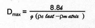
(1)
where: Dmax = largest clast size
k = strength
g = gravitational acceleration
p = density of clast or matrix
k = strength
g = gravitational acceleration
p = density of clast or matrix
Now, the Bingham plastic rheology model for a debris flow states that the critical shear stress for movement (Tcrit) equals the strength of the debris (k); thus, Tcrit = k [29]. Although some large debris flows may be turbulent, Hampton [in 29], who used reasonable values for flow strengths and densities demonstrated that even large fast debris flows would probably be laminar and not turbulent; equation (2), called the Hampton Number [29], shows this relationship.
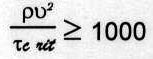
(2)
where: p = flow density
u mean = flow velocity
Tcrit = critical shear stress needed for movement
u mean = flow velocity
Tcrit = critical shear stress needed for movement
It follows that if the strength is equal to the critical shear stress for movement to occur, then the minimum mean flow velocities are easily calculated using equation (3):
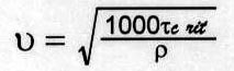
(3)
The largest clast size (Dmax) as field measured, gravitational acceleration of 9.8 m/s3, matrix density (P matrix) of 1682.0 kg/m2 and appropriate clast density (pclast) as indicated earlier was used in equation (1) to calculate strength (i.e. critical shear stress); the results are indicated in TABLE 1. These strengths (k) or critical shear stresses (Tcrit) along with a conservative "flow density" (p) of 1800 kg/m3 (to account for the 5-10% entrainment of clasts within the debris matrix) were used in equation (3) to calculate the minimum mean flow velocities also shown in TABLE 1. The calculated velocities are similar to previously reported rates of 20 m/s [29] and even up to 35 m/s [31] for debris flows. On continental slopes, earthquakes, tide or storm surges are required to initiate movement of debris flows; "a slope is a necessary prerequisite" [36].
TABLE 1: Minimum Mean Flow Velocities of Kingston Peak Debris Flows
| Section | Clast Type | Dmax m | Roundness | Critical Shear Stress or Strength kg/(m)(s2) |
Mean Flow Velocity m/s |
| Horse Thief Springs |
Dolomite (Beck Spring) |
0.5 | Subrounded | 1,900 | 32 |
| Old House | Black Chert | 0.4 | Angular | 430 | 15 |
| Flying Saucer | Black Chert | 0.5 | Subangular | 540 | 17 |
| Silver Rule Mine | Quartzite | 0.6 | Subrounded | 650 | 19 |
Warm water is a favorable condition for the precipitation of calcium carbonate. The matrix of the carbonate layer (or layers) at or near the top of the puddingstones was verified by seventeen element analysis. The results indicate an average loss on ignition of 40.5%. Ca/Mg ratios fall in the range of either a sedimentary dolomite or calcitic dolomite [4]. Samples from the Crystal Spring section showed the highest amount of terrestrial input (i.e. Si02, Al203, and Ti02); whereas, the sample from Megaclast Ridge measured the lowest. The general trend is lesser terrestrial input towards the southeast. However, many dolomite layers are heavily brecciated and contain clasts of Beck Spring Dolomite including black chert and are interpreted as limy debris flows (e.g. Crystal Spring & Silver Rule Mine). Individual debris flows are known to deposit separate tongues of material that have quite different textual characteristics [29]. While following the single (and only) layer at Silver Rule Mine the dolomite disappeared into puddingstone. Other dolomite layers in the Kingston Peak Formation are not as brecciated and contain thick bands of black chert (e.g. Flying Saucer). About 500 m west from Flying Saucer the lowest dolomite layer was followed where it tapers out into puddingstones and becomes more brecciated. Just adjacent to this taper are chunks (>1 m in length) of brecciated dolomite that appear as if they broke-off from the dolomite layer and floated away within the puddingstones. The first 60 cm of the underlying puddingstone in this area appears smashed or contorted. These discontinuous "layers" may actually be olistostromes (slide accumulation) of uppermost Beck Spring Dolomite that slid and flowed into place concurrently with the puddingstones as they detached from the source region to the north. Brecciation could be caused by sliding, by broken fragments transported together, and by dewatering processes induced by earthquakes associated with sedimentary movements on faults [51].
Megabreccia Unit (KP)
Polymictic (more than one rock type) and monomictic breccias and megabreccias occur at the Kingston Range. They are clast supported layers with mostly subangular cobbles and boulders. At first glance, one could easily call many breccias "monomictic"; however, upon close examination most "monomictic" breccias are in reality "nearly monomictic". Polymictic and nearly monomictic breccias are comprised of clasts of dolomite, quartzite (or possibly granophyre), and lesser amounts of diabase, chert, and other clasts. "Nearly monomictic" breccias contain about 95% gray dolomite and only about 5% quartzite and other clasts. Most polymictic breccias rhythmically alternate with thin sandstone beds (e.g. Flying Saucer and Old House sections). They range in thickness from 2.0-4.0 m including sandstone beds about 20-50 cm thick. Many of the breccia beds are entrained with the same type of coarse brown sandstone that comprises the alternating sandstone beds. Cross-bedding in some sandstones indicates a southerly flow. The clasts of some sandy breccias become separated by about 5-25% matrix. The clasts of Beck Spring Dolomite within this unit are mostly subangular to angular while the clasts of supposed quartzite and diabase are usually subrounded to rounded. The largest clasts (Dmax) within the megabreccias typically measured from 1.5 m to 4.0 m long. This does not include the huge megaclasts. One block of Beck Spring Dolomite sits on top of the dolomite layer at the Rounded Hills section and measures 5 m thick by 12 m in strike length. This block is stratigraphically lower than the 40 m thick by 380 m long block observed stratigraphically higher in the formation measured near Silver Rule Mine. The 380 m megaclast extends through the overlying deposits and a rather large portion of it appears in depositional contact with the overlying Noonday Dolomite. Polymictic megabreccia composed of about 60% Beck Spring Dolomite clasts and 40% quartzite clasts surrounds the 380 rn long block. An interesting feature of the enormous dolomite blocks is their relation to the surrounding megabreccia. Most of debris in the breccias closer to the blocks becomes more monomictic with dolomite clasts similar to the block itself. This indicates that the blocks were breaking apart around the edges and generating much of the breccia debris while sliding. Similar processes occurred in the Split Mountain sturzstrom when rock debris was crushed and torn away from a larger "core stone" [17, p. 159]. There are an abundance of rounded to subrounded clasts of quartzite that occur in close proximity to and even within jigsaw puzzle monomictic megabreccias surrounding the giant clasts. To account for this, it seems reasonable that the harder quartzite clasts, *that probably originated from a more distant source [16], were presumably already in turbulent transport during the breakup and sliding of the dolomite blocks. The source area, about 4 km to the north of Megaclast Ridge was examined for two days. The point where the Noonday Dolomite directly overlies the Crystal Spring Formation was seen. From this point southward the thickness of the Kingston Peak Formation increases abruptly and the Noonday appears to overly the Kingston Peak as an angular unconformity. The Beck Spring Dolomite, even those sitting on the Crystal Spring Formation, appear as giant slide blocks. The northern tops of the slide blocks are in contact with the overlying Noonday Dolomite. Moving southward along the Noonday/Kingston Peak contact the following sequence was
 observed: brecciated Beck Spring megaclast, sandy breccia, brecciated Beck Spring megaclast, and sandy breccia. The sandy breccia is very poorly sorted and consists of about 75% probable debris from the Crystal Spring Formation and 25% from the Beck Spring Dolomite. Boulders of dolomite, 2-3 m long, occur near the contact with the Noonday. Boulders of rounded quartzite 50 cm diameter are quite numerous throughout. Deposits similar to the Lower Sandstone Unit and Puddingstone Unit were not seen at the source area.
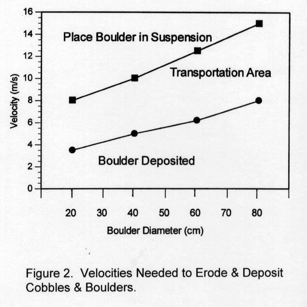
At the Old House section each clast supported polymictic rhythmite is inverse-to-normally graded with the largest clasts deposited in roughly the middle of each breccia bed. This suggests a very high energy environment nearer to the source [29]. Disorganized beds are closest to the source followed downcurrent by inverse-to-normally graded, graded, and finally graded-stratified beds [29]. The best example of graded to perhaps graded-stratified beds occurs at Horse Thief Springs. Throughout the range, good outcrops of cobble-boulder breccias have a fluid-like morphology and appear as suspension deposits that suddenly dropped from suspension and froze in place. As current velocity increases the frequency and force of "impact pulses" increase and some boulders begin rolling and jumping (i.e. bed load) [35]. In a flow of given depth, larger particles move upward or higher into the current and encounter faster-moving water than smaller particles [11]. Experiments with thin sheets of swift-moving water and pebbles caused the pebbles not only to travel upward through the water, but some were projected out of the water and into the air [11]. Turbulence causes more boulders to jump higher into the flow and contact with the sea floor decreases; then there is "considerable suspended load within the water" [35, p. 99]. Figure 2, after [35] shows the velocity needed to place a particular size boulder in suspension, velocities needed to keep it in flow, and the velocity when it would be deposited.
The power of moving water is remarkably displayed when waves and currents from large storms "carry away" large blocks of concrete weighing up to 2.85 x 10⁶ kg [6], which implies a 5 m x 10 m x 20 m block of dolomite. Another example of possible suspension (i.e. "water-laid") process occurred in Hawaii where a 365 m high "surge" from a colossal wave scoured the Islands and deposited two layers of clast supported basaltic debris [26]. The combined deposit is 5 m thick and thins upslope; the lower layer contains subrounded to rounded clasts, 3 cm -1 m diameter; whereas the upper layer contains subangular to angular clasts ranging from 20 cm -1.5 m diameter. The deposit was triggered when a rapid submarine landslide displaced the ocean water creating a wave that rushed up onto the Islands, carrying with it rock debris from the near shore shelf and beach [26]. The roundness of clasts may be attributed to abrasion in tractive transport [17]. The cross-bedded sandstones that cap the breccia and megabreccia beds are interpreted as traction deposits [36]. Each traction deposit alternating with the suspension breccias formed when the current slowed to a point where it began to deposit the sand and pebbles. However, the current was still moving swiftly enough to create the tractional effects in the particles deposited. This effect is produced by depositing/reworking currents [11].
The question is what could cause suspension breccias and megabreccias with alternating sandstones to form? Several processes, mostly catastrophic, are now believed to form breccias and megabreccias. These include tectonism [e.g. faulting and volcanic explosions, see 4], landslides [44], tsunami surge deposits generated from submarine landslides [26,27], and sturzstroms [17,32,37]. Earthquakes are associated with or cause most of these events. Faulting is graphically demonstrated in major earthquakes when a "catastrophic slip" event reaches ground surface and breaks apart the topography [44, p. 255]. The most marked sedimentary effects of faulting are the conglomerates, sedimentary breccias and melanges deposited in narrow zones along active fault scarps. "A coarse conglomeratic facies develops because the upthrown block is subaerially exposed immediately adjacent to a sinking basin" [44, p. 262]. This fault "relief"can lead to subaerial and submarine landslides, rock falls, debris flows, and associated chaotic deposits called olistostromes which include breccias [44]. The Noonday Dolomite that rests on the Crystal Spring Formation and underlying crystalline basement, about 4 and 5 km to the north [e.g. 16], respectively, of the measured sections, implies a vertical displacement on the fault [e.g. 15,53] in that region of about 950 m (350 m thickness of the Beck Spring Dolomite + 600 m thickness of Crystal Spring Formation) [16]. However, sections of Kingston Peak Formation imply a total throw at least as great as the thickness of the formation itself. The 1600 rn thick Megaclast Ridge section then requires at least 1600 m of displacement. It is not presently known if this displacement is attributed to a single fault or a series of step faults.
Sturzstroms are long runout landslides or giant rock avalanches [22] that can occur in subaerial or subaqueous environments; the word actually means "fall-stream" [32] because the debris initially falls or collapses down a steep slope and flows a considerable distance across gentle to flat ground [4]. They are considered "the most catastrophic of all forms of mass movement" [4] and are known to "flow" with mean flow velocities ranging from 50 to 100 m/s [31]. The catastrophic "movement and emplacement of a sturzstrom deposit involves enormous quantities of energy thus making preservation of fossils highly unlikely" [17]. The critical characteristics of a sturzstrom include: fluid-like morphology; sheet-like geometry; long runout; total volume > 1 X 10⁶ m3; preserved headscarp stratigraphy; reverse grading; and jigsaw puzzle breccia [37]. The Kingston Range breccias of the measured sections have a fluid-like morphology, sheet-like geometry, some (albeit not abundant) jigsaw puzzle fabric, and volumes greater than required even when only single layers of breccia are considered. Reverse grading occurs at the Silver Rule Mine section with the 380 rn clast at or near the top; likewise, the largest clasts, meters across, occur at or near the top of the well studied Fish Creek [42] and the 66 m thick Split Mountain sturzstroms [17]. The megaclasts of the Split Mountain sturzstrom are thought to have been transported, from start to finish, while riding on top of the debris; the only other possibility is that megaclasts were buoyed upward by internal mixing and turbulence [17]. It is now well accepted that rockfalls with volumes greater than approximately 1 X 10⁶ m3 "runout" over great distances. The runout distance can be assumed to be at least 5 km (the distance from the measured sections to the source area), which falls within the range of many sturzstroms [32]. The nature of the deposits imply that the runout was probably greater but can not be determined at this time because the measured sections are essentially parallel to the paleoslope (i.e. perpendicular to the flow). To determine longer runout would require a field study of the formation at mountain ranges south of the Kingston Range. However, some [e.g. 55] believe the debris of the Kingston Peak Formation extends 20-25 km into the basin. About 70 major submarine landslides around Hawaii have traveled over 20 km [27]. "Preserved headscarp stratigraphy" means that debris from a stratigraphic layer at the source area should be found in a particular lithologic domain in the slide with little mixing with other source layers [37]. At the Kingston Range, breccias surrounding the giant blocks show "little mixing". Some polymictic breccias seem to be composed chiefly of rocks from the Crystal Spring Formation which would imply that these rocks were mixed and deposited together with "little mixing" with other deposits from other formations. The Fish Creek Sturzstrom reveals similar characteristics to those found in the Kingston Peak breccias [32]. Clast is polymictic and there is a "progressive loss" of internal jigsaw puzzle fabric going away from the source area where clasts, up to 2 m long, become separated by matrix giving the appearance of a debris flow [32]. This could explain why some breccias, especially at Old House, Rounded Hills, Horse Thief Springs, and the source area have a good amount of sandy matrix. Now, if the lower Kingston Peak Formation was deposited on an "inner shelf"atop underlying Beck Spring Dolomite and Crystal Spring Formation, this would imply a water depth <60 rn prior to faulting. If a single catastrophic slip occurred, most of the displacement was probably on the downthrown side of the fault. Shelf water, sediments, debris (e.g. large quartzite boulders and other clasts), and huge slide blocks would then flow and drop off the uplifted area over a giant fault scarp and into the basin.
Debris flow and sturzstrom characteristics occur in this unit; therefore, certain key processes can be postulated to explain the depositional environment. In a subaqueous environment they could include Bingham plastic rheology (already discussed in Puddingstone Unit); grain flow in fluid medium; and acoustic fluidization [37]. The fluidized grain flow hypothesis suggests that rocks in transport during the avalanche impact each other throughout the slide [22] and "flow into place like some sort of viscous fluid" [37]. This theory presupposes a turbulent flowing motion throughout the landslide mass and mud could form the fluid component between clasts [37]. However, keeping the rock mass fluidized in this way alone requires too much energy [37]. Some [31] believe the term "grain flow" should be replaced with "granular flow"; and sturzstroms, in particular, are large rapid inertial granular flows (i.e. fluidized granular flows). In this case mechanisms of flow in a subaqueous environment are upward motion of a fluid that supports part of the sediment weight; mechanical dilation under shear and separation of particles through collision and rebound; and, grain separation by vibrational (acoustic) energy. Acoustic fluidization occurs as groups of clasts (not individual clast collisions - grain flow), organized into elastic waves larger than the size of individual clasts, pass through the debris [22]. This process places some rocks in compression and others in extension which allows plastic strain to accumulate. This failure is dynamic; stresses change rapidly with time as compressions and rarefactions shift through the rock mass, allowing the entire mass to slide. This process conserves energy at a much higher rate than grain flows; however, acoustic fluidization and dispersive grain flow are closely related. As the acoustic field becomes stronger individual grains spend less time moving together as parts of an elastic wave and more time colliding as individual rocks; thus, grain flow is the high energy end member of acoustically fluidized debris [22]. It is known that large landslides may experience fluidization during strong seismic events and the term "earthquake fluidization" may be considered as a subset of acoustic fluidization [37, p. 197]. Earthquakes add vibrational energy to these flows and although the process can operate in a complete vacuum, "the presence of a fluid probably enhances the flow" [22, p. 47]. We believe rapidly flowing water over the cataract enhanced the flow even more. Although some of the deposits have some sturzstrom characteristics, the deposits are a combination of debris flows and rock falls. As sediment concentration increases, yield strength increases and flows transition from hyperconcentrated streamflow to slurry flow to granular (i.e. collisional) flow. Processes controlling flow behavior depend on deformational rate (i.e. velocity). Frictional and viscous forces dominate at lower velocities and in finer grained mixtures; whereas, rate-dependent inertial forces dominate at higher velocities and in coarser grained mixtures. "As velocity increases, grain support mechanisms change from low-energy varieties (buoyancy, cohesion, structural support) to progressively higher energy mechanisms (turbulence, dispersive stress, fluidization)" [31, p. 1 ]; therefore, velocities higher than matrix-supported debris flows (i.e. puddingstones) are needed for clast-supported debris flows [29]. Overall, we interpret the Megabreccia Unit as clast-supported debrites [29] with associated rock falls and slide blocks.
Megaclast Deposits at the Megaclast Ridge Section (KP)
As shown in Figure 1, the Puddingstone Unit at this location seems to correlate quite well with the other locations; however, above the Puddingstone Unit the remaining Kingston Peak Formation as a whole is twice as thick compared to the other studied areas. This correlation may imply that after deposition of the debris flows (i.e. puddingstones), the shelf in this area underwent additional collapse. Finer particles may have been winnowed (or bypassed) from the north-northwest and funnelled to this deeper area as turbidites. At least 10 giant megaclasts, composed of the Beck Spring Dolomite and Crystal Spring Formation, measure hundreds of meters (up to about 1 km) along their largest axis. They are interpreted as blocks of sedimentary material emplaced as slides and slumps called olistoliths [39]. Evidences for the olistolith interpretation are contorted appearance rocks within the megaclast itself; underlying monomictic breccia which represents breakage during sliding [39]; and many small-scale irregular folds that occur in conjunction with larger folds [20]. The blocks of Beck Spring Dolomite are brecciated mainly around the edges. Some blocks of the multi-sedimentologic Crystal Spring Formation were redeposited as highly folded slabs while others maintain the original order of parallel strata intact. Some of the small scale folds, are very tightly folded and occur nearest to the Beck Spring megaclasts. Some folds < 1 m across exhibit apparent tension cracks probably caused when the elastic limit was reached during folding. Such tight folds probably indicate that some of the sedimentary beds of the Crystal Spring Formation were not lithified during redeposition into the Kingston Peak Formation. At this location it is proposed that, during debris flow and turbidity flow deposition, large elongated masses of Beck Spring Dolomite detached from the source area and slid atop the upper Crystal Spring Formation of the source area. This activity caused brecciation of the Beck Spring megaclasts and possibly began to fold some of the underlying Crystal Spring Formation rocks simultaneously until they were subsequently dislodged, slid over the scarp, and stacked into place "card-deck style" [39]. It is interesting that a debris flow is the first deposit generated when this type of failure occurs [39]. Cohesive debris flows are known to transport enormous slabs on a cushion of overpressurized or liquified mud; the resultant deposit is called a megaturbidite which are thought to originate as a result of earthquakes of at least magnitude 7.0 [29, pp. 47-48, 341].
Upper Conglomeratic Sandstone Unit (KP)
This unit typically shows bedding and ranges in thickness from 25 m in the northwest to 250 m in the southeast. The section near Silver Rule Mine is somewhat contorted. Moving northwestward along the Kingston Peak/Noonday contact (i.e. towards the upper part of the 380 m long megaclast), clasts comprising about 20% of the unit appear "frozen" in place vertically and at other angles contrary to bedding. About 200 m east of the 380 m block a double-car garage size Beck Spring Dolomite megaclast was observed within sandy breccias of this unit. Breccia beds and dispersed clasts of pebbles, cobbles, and boulders (usually up to about 50 cm long) persist throughout the unit at most other locations. The availability of clasts probably diminished, as basement faulting ceased [19], and the entrainment of finer sediments occurred as a result of the oncoming transgressive waters that deposited the Noonday Dolomite. An analog to this unit may be the 75 m thick deposit above the Split Mountain sturzstrom. This deposit includes turbidites, grain flow sandstones, and boulder bearing sandstones interstratified with mudstones interpreted as a rapid invasion of marine waters associated with "significant tectonic reorganization" [17, p.154]. We couldn't have described this unit any better.
The Associated Turbidites (KP)
Several observed beds, easily interpreted as turbidites, appear intimately related to the forementioned deposits. High concentration turbidity currents produce a great variety of bed types or facies. These include (1) disorganized gravel; (2) disorganized pebbly sand; (3) stratified gravel; ( 4) inversely graded gravel; (5) normally graded gravel; (6) graded-stratified gravel; (7) stratified pebbly sand; (8) inversely graded pebbly sand; (9) normally graded pebbly sand; (10) graded-stratified pebbly sand; (11) thick/medium-bedded disorganized sands; (12) parallel-stratified sands; (13) poorly sorted muddy sands; (14) organized sand-mud couplets; (15) structureless silts; and, (16) muddy silts [29]. Several of these turbidites were observed in the field. The Silver Rule Mine section contains an interesting succession of deposits while going upsection. For instance the lower puddingstones are interlayered with sandstone, breccia and mudstone and the carbonate is loaded with black chert and Beck Spring Dolomite clasts. The upper portion of the Puddingstone Unit and overlying strata begin a trend of inversely graded layers. First, there is a 4.5 m thick medium sandstone that grades upward into a cobble-boulder breccia followed by 13 m of puddingstone and then a 6 m thick medium grained sandstone with pebbles toward the top. This is followed by a 9 m thick breccia layer with D100 = 25 cm, which is then followed by a 20 m thick succession of "rhythmites".
Each "rhythmite" is inversely graded and ranges in thickness from 30-90 cm. Each bed (from bottom to top) includes 2.5-5 cm shale or mudstone, 22.5-75 cm thick medium grading up to coarse sandstone; and a 5-10 cm pebble layer. These reverse graded beds pass rapidly up into structureless pebbly sand and are interpreted as the "inversely graded pebbly sand" turbidite facies, which is formed by "rapid deposition by frictional 'freezing' of a traction carpet driven along by shear at the base of the flow" [29, p. 51]. About halfway upsection through these "inversely graded pebbly sands" is a 1.5 m thick breccia bed. After these rhythmites, the breccias were deposited and the general trend of the Kingston Peak Formation near Silver Rule Mine is a coarsening upward sequence with the giant 380 m long megaclast at or near the top of the formation.
High-density turbidity currents are also known to travel at speeds of 100 km/hour [36]. The 1929 Grand Banks turbidity current, caused by the 7.2 magnitude earthquake in the Laurentian Channel (eastern Canada), deposited a 1 m thick graded fine sand to silt layer in a water depth of about 5200 m. Initially it suspended gravel 2 cm in diameter and deposited it in depths from 1600-4500 m [29].
CONCLUSION
We suggest that normal catastrophic faulting and tectonic denudation from high magnitude earthquake activity associated with large-scale catastrophic plate tectonics [2] generated the debris for the Kingston Peak Formation. An initial sudden collapse of the pre-Flood ocean floor caused by faulting in the crust [1] converted the "shelf' into a "slope" environment. Debris flows were generated when clasts from underlying formations were swept up into a thick, rapidly flowing slurry of sands and carbonaceous cement which laid the initial "puddingstone" deposits with associated turbidites. The water column above the collapsed zone also fell and a series of seismic sea waves were generated [3]. The Nopah upland may have risen by elastic upward rebound [3]. This caused extreme breakup of the topography accompanied by massive amounts of wave-ridden shelf water to be displaced southward. Large-scale rock debris was carried in surges over a great waterfall with a slope of perhaps 600 as earthquakes persisted. We suggest that rock falls spawned the generation of the submarine clast-supported debris flows or suspension-sturzstrom deposits (e.g. magabreccias). Acoustically fluidized flowing sheets of rock debris and sediment-laden seawater <60 m deep rapidly rode over the cataract. Preserved traction deposits between megabreccia beds testify of rapid flowing suspension of rock debris. These rhythmic suspension and traction deposits probably testify of a continual flow of debris over high relief that lessened as the basin was filled. Velocities of the water-rock flows were greatest near the area of relief and lessened outward from it. Each successive clast-supported debris flow or suspension-sturzstrom deposit overrode the preceding deposit. The facies change from mostly breccias, megabreccias, traction sands, and turbidites in the northwest area to mainly high concentration thick bedded turbidites called megabeds [29] with associated gigantic clasts to the southeast may represent a second drop over another fault (i.e. step fault). Although the turbidites in this area were deposited rapidly, the giant megaclasts or olistoliths remained intact (much less pulverization) and were deposited by slumping and sliding. Velocities of debris flows (50 km/hr), turbidites (50-100 km/hr), and sturzstroms (180-360 km/hr) combined with a continual sediment supply and continual flow would allow the entire Kingston Peak Formation at this location to be deposited in a matter of hours.
We have established the stratigraphic thicknesses and the cataclysmic nature of the deposits of the Kingston Peak Formation; however, a good structural thesis is needed to establish the nature of the large scale crustal faulting. Detailed field and laboratory studies are needed of the Crystal Spring Formation and Beck Spring Dolomite to verify that the "shelf' model is correct. Petrologic and geochemical studies of the Beck Spring compared to the Kingston Peak dolomites, and "quartzite" boulders compared to quartzite and granophyre of the Crystal Spring Formation should ensue.
It seems that the waters were "exceedingly violent on the earth..." [Genesis 7:19 in 13].
ACKNOWLEDGMENTS
This study was conducted in association with graduate studies by both authors while enrolled at the Institute for Creation Research (ICR). Dr. Steven A. Austin, chairman of the Geology Department at ICR, supervised this project. Dr. Kurt P. Wise of Bryan College contributed significantly to field descriptions and analysis.
REFERENCES
- Austin, S.A., and Wise, K.P., The Pre-Flood/Flood Boundary: As Defined in Grand Canyon, Arizona and Eastern Mojave Desert, California, Proceedings of The Third International Conference on Creationism, R.E. Walsh et al., Editors, 1994, Creation Science Fellowship, Inc., Pittsburgh, PA, pp. 37-47.
- Austin, S.A., Baumgardner, J.R., Humphreys, D.R., Snelling, A.A., and Vardiman, L., and, Wise, K.P., Catastrophic Plate Tectonics: A Global Flood Model of Earth History, Proceedings of The Third International Conference on Creationism, R.E. Walsh et al., Editors, 1994, Creation Science Fellowship, Inc., Pittsburgh, PA, pp. 609-621.
- Bascom, W., Waves and Beaches, The Dynamics of the Ocean Surface, 1964, Anchor Books, Doubleday and Company, NY.
- Bates, R.L., and Jackson, J.A., Glossary of Geology, 2nd Ed. 1980, American Geological Institute, Falls Church, VA.
- Calzia, J.P., and Troxel, B. W., Absolute age constraints on the age and tectonics of the middle and late Proterozoic Pahrump Group, southern Death Valley, California, Geological Society of America Abstracts with Programs, 25:5(1993) p. 17.
- Carson, R.L., The Sea Around Us, 1961, Mentor (Penguin Group), NY, p. 116.
- Condie, K.C., Plate Tectonics & Crustal Evolution, 3rd Ed., 1989, Permagon Press, NY.
- Crittenden, M.D., Jr., Nomenclature and correlation of some upper Precambrian and basal Cambrian sequences in western Utah and southeastern Idaho, Geological Society of America Bulletin, 82(1971) pp. 581-602.
- Davis, R. A., Jr., Depositional Systems, 1983, Prentice-Hall, Inc., Englewood Cliffs, NJ.
- Dickinson, W.R., 1977, Paleozoic plate tectonics and the evolution of the Cordilleran continental margin, Paleozoic paleogeography of the western United States, Pacific coast paleogeography symposium 1, J.H. Stewart et al., Editors, The Pacific Section Society of Economic Paleontologists and Mineralogists, Los Angeles, California, pp. 137- 155.
- Friedman, G.M., and Sanders, J.E., Principles of Sedimentology, 1978, John Wiley and Sons, NY.
- Glover, T. J., Pocket Ref, 1st Edition, 1994, Sequoia Publishing, Inc., Littleton, CO.
- Green, J.P., Sr., editor, The Interlinear Bible, Hebrew-Greek-English, One Volume Edition, 2nd Edition, 1986, Hendrickson, Peabody, MA.
- Harland, W.B., The Proterozoic glacial record, Proterozoic Geology: Selected Papers from an International Proterozoic Symposium, Geological Society of America Memoir 161 (1983) pp. 279-288.
- Harrison, J.E., and Reynolds, M.W., Western U.S. continental margin: a stable platform dominated by vertical tectonics in the late Precambrian: Geological Society of America Abstracts with Programs, 8:6(1976) p. 905.
- Hewett, D.F., Geology and mineral resources of the Ivanpah quadrangle, California and Nevada, U. S. Geological Survey Professional Paper 275, (1956) pp. 25-29.
- Kerr, D.R. and Abbott, P.L., Miocene Subaerial Sturzstrom Deposits, Split Mountain, Anza-Borrego Desert State Park, Sturzstroms and Detachment Faults, Anza-Borrego Desert State Park, California, P.L. Abbott and D.C. Seymour, Editors, 1996, South Coast Geological Society, Inc., Santa Ana, CA., pp. 149-163.
- Labotka, T.C. and Albee, A.L., Late Precambrian depositional environment of the Pahrump Group, Panamint Mountains, California, California Division of Mines Special Report 129 (1977) pp. 93-100.
- Levy, M., and Nicholas, C., Tectonic subsidence analysis of the Paleozoic passive margin in eastern California and adjacent Nevada, Geological Society of America Abstracts with Programs, 17: 7(1987) p. 745.
- Lewis, D.W., and McConchie, D., Practical Sedimentology, 2nd Edition, 1994, Chapman Hall, NY.
- Marion, M.L., and Osborne, R.H., Petrology, petrochemistry, and stromatolites of the Middle to Late Proterozoic Beck Spring Dolomite, eastern Mojave Desert, California, Canadian Journal of Earth Science, 29(1992), pp. 2595-2609.
- Melosh, H.J., The mechanics of large rock avalanches, Reviews in Engineering Geology, Volume VII: Debris Flows/Avalanches: Process, Recognition, and Mitigation, J.E. Costa and G.F. Wieczorek, Editors, 1987, The Geological Society of America, Boulder, CO., pp. 41-49.
- Miller, J.M.G., Wright, L.A., and Troxel, B.W., The Late Precambrian Kingston Peak Formation, Death Valley region, California, Earth's pre-Pleistocene glacial record: International Geological Correlation Programme Project 38: Pre-Pleistocene Tillites, M.J. Hambrey and W.B. Harland, Editors, 1981, Cambridge University Press, pp. 745-748.
- Miller, J.M.G.,Upper Precambrian glaciomarine shelf sedimentation, Kingston Peak Formation, eastern California, 1 11th Int'l Congress on Sedimentology Abstracts of Papers, (1982) p. 77.
- Miller, J.M.G., Glacial and syntectonic sedimentation: The upper Proterozoic Kingston Peak Formation, southern Panamint Range, eastern California, Geological Society of America Bulletin, 96(1985) pp. 1537-1553.
- Moore, J.G., and Moore, G. W., Deposit from a giant wave on the Island of Lanai, Hawaii, Science, 226(1984) pp. 1312-1315.
- Moore, J.G., Normark, W.R., and Holcomb,R.I., Giant Hawaiian underwater landslides, Science, 264 (1994) pp. 46-47.
- Oard, M.J., Submarine Mass Flow Deposition of Pre-Pleistocene "Ice Age" Deposits, Proceedings of The Third International Conference on Creationism, R.E. Walsh et al., Editors, 1994, Creation Science Fellowship, Inc., Pittsburgh, PA, pp. 407-418.
- Pickering, K.T., Hiscott, R.N., and Hein, F.J., Deep Marine Environments, Clastic Sedimentation and Tectonics, 1989, Unwin Hyman Ltd., London.
- Pierce, D.E., and Awramik, S.M., Age and significance of microfossils from the Meso-Neoproterozoic Pahrump Group, eastern California, Geological Society of America Abstracts with Programs, 26:2(1994) p. 81.
- Pierson, T.C., and Costa, J.E., A rheologic classification of subaerial sediment-water flows, Reviews in Engineering Geology, Volume VII: Debris Flows/Avalanches: Process, Recognition and Mitigation, J.E. Costa and G.F. Wieczorek, Editors, 1987, The Geological Society of America, Boulder, CO., pp. 1-12.
- Rightmer, D.A. and Abbott, P.L., The Pliocene Fish Creek Sturzstrom, Anza-Borrego Desert State Park, Southern California, Sturzstroms and Detachment Faults, Anza-Borrego Desert State Park, California, P.L. Abbott and D.C. Seymour, Editors, 1996, South Coast Geological Society, Inc., Santa Ana, CA., pp. 165-184.
- Schermerhorn, L.J.G., Late Precambrian mixtites: Glacial and/or nonglacial?, American Journal of Science, 274(1974) pp. 673-824.
- Sears, J.W., and Price, R.A., The Siberian connection: A case for Precambrian separation of the North American and Siberian cratons, Geology, 6(1978) pp. 267-270.
- Seibold, E., and Berger, W.H., The Sea Floor, An Introduction to Marine Geology, 3rd Edition, 1996, Springer-Verlag, Berlin, Heidelberg, New York.
- Selley, R.C., Applied Sedimentology, 1988, Academic Press, San Diego, CA.
- Shaller, P.J., and Shaller, A.S., Review of Proposed Mechanisms for Sturzstroms (Long-Runout Landslides), Sturzstroms and Detachment Faults, Anza-Borrego Desert State Park, California, P.L. Abbott and D.C. Seymour, Editors, 1996, South Coast Geological Society, Inc., Santa Ana, CA., pp. 185-202.
- Shepard, F.P., Submarine Geology, 3rd Edition, 1973, Harper and Row, NY.
- Steen, 0., and Andresen, A., Deformational Structures associated with Gravitational Block Gliding: Examples from Sedimentary Olistoliths in the Kalvag Melange, Western Norway, American Journal of Science, 297(1997), pp. 56-97.
- Stevens, R.L., Markov-chain analysis as a pedagogic, tool, Journal of Geological Education, 38(1990) pp. 288-293.
- Stewart, J.H., Initial deposits in the Cordilleran Geosyncline: Evidence of a Late Precambrian (<850 m.y.) continental separation, Geological society of America Bulletin, 83(1972) pp. 1345-1360.
- Stewart, J.H., and Suczek, C.A., Cambrian and latest Precambrian paleogeography and tectonics in the western United States, Paleozoic paleogeoqraphy of the western United States Pacific coast paleogeography symposium I, J.H. Stewart et al., Editors, 1977, The Pacific Section society of Economic Paleontologists and Mineralogists, Los Angeles, CA, pp. 1-17.
- Stewart, J.H., Latest Proterozoic and Cambrian rocks of the western United States?an overview, Paleozoic paleography of the western United States-II, J.D. Cooper and C.H. Stevens, Editors. 1991, Pacific Section Society Economic Paleontologists and Mineralogists, 67, pp. 13-38.
- Suppe, J., Principles of Structural Geology, 1985, Prentice-Hall, Inc., Englewood Cliffs, NJ.
- Troxel, B.W., Sedimentary rocks of the late Precambrian and Cambrian age in the southern Salt Spring Hills, southeastern Death Valley, California, California Division of Mines Special Report 92, (1967) pp. 33-41.
- Troxel, B.W., and Wright, L.A., Late Precambrian history derived from the Kingston Peak Formation, Death Valley region, California, Geological Society of America Abstracts with Programs, 9:4(1977) p. 517.
- Troxel, B.W., Wright, L.A., Williams, E.G., and McMackin, M.R., Provenance of the late Precambrian Kingston Peak Formation, southeastern Death Valley region, California, Geological Society of America Abstracts with Programs, 17:6(1985), p. 414.
- Troxel, B.W., McMackin, M.A., and Calzia, J.P., Comment and Reply on "Late Precambrian tectonism in the Kingston Range, southern California, Geology, 15:3(1987), pp. 274-275.
- Tucker, M.E., Diagenesis, geochemistry, and origin of a Precambrian dolomite: the Beck Spring Dolomite of eastern California, Journal of Sedimentary Petrology, 53:4(1983) pp. 1097-1119.
- Tucker, M.E., Formerly aragonitic limestones associated with tillites in the Late Proterozoic of Death Valley, California, Journal of Sedimentary Petrology, 56:6(1986) pp. 818-830.
- Tucker, M.E., Sedimentary Rocks in the Field, 2nd Edition, 1996, John Wiley and Sons, Inc.
- Visher, G.S., Exploration Stratigraphy, 1990, PennWell Publishing Co., Tulsa, OK.
- Walker, J.D., Klepacki, D.W., and Burchfiel, B.C., Late Precambrian tectonism in the Kingston Range, southern California, Geology, 14(1986) p.15-18.
- Weisberg, J.S., and Parish, H.I., Introductory Oceanography, 1974, McGraw-Hill, NY.
- Wright, L.A., Troxel, B.W., Williams, E.G., Roberts, M.T., and Diehl, P.E., Precambrian sedimentary environments of the Death Valley region, eastern California, , Geologic features, Death Valley, California, Special Report 106, B.W. Troxel and L.A. Wright, Editors, 1976, California Division of Mines and Geology, Sacramento, CA, pp. 7-15.
- Wright, L.A., Overview of the Proterozoic & early Cambrian depositional environments of the Death Valley region, Geological Society of America Abstracts with Programs, 20:3(1988), p. 244.