The Paluxy River Tracks
by John D. Morris, Ph.D.
It has been over a hundred years since the concept of evolutionary uniformitarianism began to be taught as scientific fact. With only a few isolated exceptions up until the past decade, every scientific discussion, every academic lecture, and every technical article that dealt with the past was centered around the framework of evolutionary uniformitarianism.
In the last ten or fifteen years, however, many scientists and laymen alike are waking up to the fact that much solid scientific evidence exists that contradicts evolutionary notions. One of the most shattering pieces of evidence comes from the Paluxy River basin in central Texas, near the town of Glen Rose, where fossilized tracks of man and dinosaur appear together.
History of the Find
The Paluxy River is a paradox in itself. At normal water levels it sparkles calmly through the area and empties into the nearby Brazos River. Often, for several months of the year it is completely dry. At other times it changes into a raging torrent. The river averages a drop of 17 feet per mile and is the second swiftest river in Texas.
The local residents are very much aware of the power of the Paluxy at flood stage. They say that during the worst floods the noise of the rushing water is drowned out by the frightening sound of boulders and rock shelves the size of automobiles grinding and breaking as they are swept downstream.
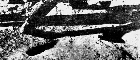 |
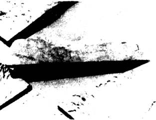
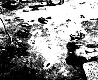
One of the worst floods of record ransacked the generally flat countryside in 1908 when the river rose 27 feet, and it was after this flood that prints began to be spotted. The erosion of a clay layer over a limestone shelf in one area revealed both human and dinosaur tracks, and the removal of an entire shelf in another area exposed others. After this it wasn't long before numerous similar tracks were discovered throughout the area.
Glen Rose is basically an agricultural community and few of the residents were aware of the meaning of the discovery. News of the prints eventually reached several universities and museums, and scientists were dispatched to study them. In 1938, a trail of brontosaurus tracks was removed from the river bottom under the supervision of the paleontologist, Roland T. Bird, and shipped to the American Museum of National History in New York, to be used in a display.1,2
Mr. Bird commented to one of the local discoverers that he must be mistaken about the man tracks, because man had not yet evolved at the time of the Dinosaurs. He claimed they must have been made by some sort of ape.
But even that possibility would not solve the problem for the evolutionists, for apes and dinosaurs living together would be almost as devastating to the geologic time table as man and dinosaur together.
The Geologic Time Frame
Almost everyone who has taken a course in geology has been required to memorize the geologic time chart. Specifics vary between individual charts, but all show a gradual evolution of life from the late pre-Cambrian period up to the present. The fossil record is sparse highly speculative before the Cambrian which is thought to have witnessed the beginning of abundant marine invertebrate life about 500-600 million years ago. The Cretaceous period is known as the age of dinosaurs and is thought to have spanned about 70 million years, ending at the very latest about 65 million years ago. But man did not appear, according to evolutionists, until around four million years ago, at the earliest.
 |
Thus, evolutionists face a dilemma. There is, at the very least, a 60-million-year gap between the age of the dinosaur and the advent of man, a gap during which there should be neither man nor dinosaur. But in Glen Rose, the fossils indicate that man and dinosaur lived not only at the same time but even at the same place! To make matters worse, the particular layer in which the footprints are found is known as the Glen Rose formation, designated lower Cretaceous, and supposedly was laid down early in the Cretaceous period, estimated about 120 million years ago.
Several uniformitarian scientists have been to Glen Rose to view the tracks. One made the following remarkable suggestion: "These man-like tracks couldn't be true man tracks, because man and dinosaur didn't live at the same time. Therefore, they must have been made by some undiscovered bipedal dinosaur with feet like human feet!" Another recognized that man must have made the tracks but explained the situation by an equally remarkable deduction: "This find doesn't disprove evolution; rather, it indicates that man appeared before dinosaurs became extinct and forces a revision of the geologic time scale."
But what a revision! Since evolutionists estimate about 600 millions years for the evolution of all life, this revision would wipe out at least 20 percent of earth history! And if the time scale has been so wrong in the most recent age, how can we trust it in the dim past?
Two samples of carbonized plant remains found in these strata provide the only real physical data for establishing a firm date according to uniformitarian assumptions. They were dated by the Carbon 14 dating method (which has been shown by creationist scientists to give ages higher than true ages). The calculated ages were 38,000 to 39,000 years before present even though they were found in strata thought to be 100,000,000 years old.3
The creationist does not face such a problem. This evidence harmonizes with a great deal of data indicating that the earth and all its strata are quite young and that all of the earth's inhabitants were created essentially at the same time. These footprints, (which everyone would agree were man tracks if situated in strata designated as recent), imply the existence of man in the Cretaceous by all modes of logical thought, by the scientific method, and by open-minded analysis of raw data.4
Proper Identification
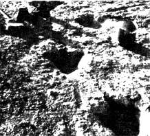
Seldom does one find a perfect footprint in the Glen Rose formation, a print that clearly shows all the features of a human foot. This is as it should be, of course, for a man walking in mud or wet sand without consciously trying to leave good tracks will slip, change stride, alter directions, stop or do other things that will mar his trail. Evolutionists have sometimes said that these markings are merely erosional features, or that they are not sufficiently detailed to be designated as man tracks. Such explanations, however, miss the mark.
 |
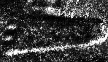
Several tell-tale signs should be present if a marking is to be identified either as a man track or as a track of any sort of animal. Walking in mud not only produces an indentation where the foot sank down, but invariably also produces a "mud up-push," a place where the surrounding mud has been pushed up higher than it was before. Generally, this occurs around the outside of the foot, behind the heel, and adjacent to the big toe and ball of the foot -- places where most of the weight of the body was borne by the mud itself. "Erosional processes" would obviously not leave a "mud up-push" or pressure ridges around an elongated marking -- features which are common in the Glen Rose tracks.
Another feature is not so easy to discern, but again is consistent with simple logic. The weight of the man or animal making the track not only deforms the mud, but causes vertical displacement below the foot. As the mud is forced down into the subsurface, it becomes compacted, the amount of compaction decreasing with depth. If the mud has any layers of discoloration or special composition, these laminations will deform beneath the print. Unless the print were originally made on a steep slope, such that the striations become visible on the surface, the only way to see these deformed laminations is by removing the print and slicing it open in a laboratory. Even in the case of a smooth, homogenous material, the pressure will tend to cause a slight line of metamorphism or change in crystallization below the track.
 |
These lines of stratification will bend downward to assume a contour essentially parallel to the contour of the foot. In the case of fossil footprints in limestone, we are dealing with rock material that once was a layer of sediments. There is no conceivable way to produce such striations artificially, but they may be present if the tracks are genuine. The absence of deformed laminations does not disprove genuineness, as may be demonstrated by a section through a plaster-of-paris mold in which a footprint had been made while the plaster was soft.
In times past, several prints were removed from the river and some of these have been sectioned in this manner. At the present time, it is illegal to remove any track from its original position and so this method of analysis is limited. Of those that have been sawed open, however (and despite some claims to the contrary), some indeed have shown the tell-tale laminations, including a "sabre-toothed tiger" track and at least one human track.
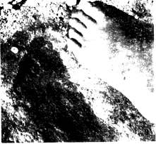
To identify a tract in situ as a bona fide man track is not an easy task. Several criteria have been established to distinguish such a track from a freak rock formation and a man track from that of an animal. First of all, the track must be consistent with the general contour of the human foot. The ball of the foot is generally most easily preserved along with the arch and heel. Individual toe depressions are rare, but generally toe markings, made as the foot left the newly formed print, are preserved.
 |
Quite commonly, as might be expected, the ball of the foot leaves the deepest impression, due to the fact that the entire weight of the body concentrates in this spot while walking, just before the opposite foot strikes the ground. At this point the heel is off the ground and mud is squeezed up between the toes, as they are pressed into the mud. Generally, these toe ridges were too fragile to be preserved, although in many cases they can be seen.
Even if a perfect human footprint were found, it would not be very convincing unless it were found as one of a series, a right-left-right-left trail of prints, all conformable to one another in size and shape. The prints should be separated by a relatively consistent length, representing the stride of the individual, and laterally by a few inches representing the natural straddle between the two feet. This trail should trend in one direction and each individual track should also be oriented in that same direction. The size of the tracks should be reasonable when compared to the length of the stride.
It is estimated that over a hundred such trails have been studied in the Paluxy River area. When an evolutionist claims that such tracks are simply erosional features (i.e., that erosion has consistently carved out man-like tracks in proper sequence) he must exercise the same blind faith and disregard for data that he uses when claiming that random mutations can produce complex ordered systems.
 |
The great majority of these tracks are in the normal range of adult foot size today, from about shoe size 7 to 13. However, a number of prints of small children are found with the larger ones. Sometimes the prints appear to be made by a moccasin or wrapping covering the print. Unconfirmed reports persist of a nearby trail so detailed that the lacing on the moccasin was clearly visible. Most, however, are unshod.5
One aspect that has caused no little amount of speculation has been the presence of giant tracks, prints made by individuals with huge feet and huge strides. It may be that humans before the Flood were much larger on the average than today. This is consistent with the fossil record, which frequently exhibits animals larger than their modern-day counterparts. Scripture may provide an insight when it claims so matter of factly that "There were giants in the earth in those days" (Genesis 6:4). Quite a few of the tracks are in the 16-inch range, but several trails are of a man with a seven-foot stride and a foot of 21 1/2 inches in length.6 Whether or not there is any connection, has not yet been determined, but several years ago the skeleton of a woman seven feet tall was excavated from the Paluxy River Basin and exhibited in the Somervell County Museum in Glen Rose.
The Problem of Carved Tracts
Accusations have arisen from still another front. Skeptics have claimed that the prints are carvings, not real prints at all. Unfortunately, this charge has some basis; in fact, several enterprising Texans from Glen Rose did make their living during the Great Depression by digging out the best tracks and selling them. The going price ranged from $10 to $25, and the dinosaur tracks were much more in demand than the man tracks. Soon, however, the best tracks were gone and a few men began to carve new tracks (especially dinosaur tracks) out of any limestone block available. As near as researchers can determine, however, only a very few "man tracks" were carved, probably less than six, certainly less than ten. These were all giant tracks, ranging from 16 to 20 inches in length and showed all features of the foot. These counterfeit tracks do not, of course, disprove the genuine tracks. In fact, it could only have been the existence of genuine tracks that made the manufacture of counterfeits profitable.
 |
These carved tracks are all produced after carving the block of limestone out of the river first. No one would ever sit down and carve out a series of imperfect tracks in the river bottom and leave these simply to rile the evolutionists! And many of the tracks have been recently uncovered (by Taylor, Dougherty and others) by excavation of the banks of the river and even in construction sites nearby. There can be no doubt whatsoever that the human tracks in situ are true tracks and not carvings. One who would make such a charge is obviously grasping at straws. A number of individuals have gone to Glen Rose to see whether there are any human tracks there, and have been unable to find them, reporting then to outsiders that the whole story is fallacious. The problem was simply that they did not know where to look. Many, of course, were skeptical and tended to jump to negative conclusions too quickly. The fact is, however, that there really are many tracks there which, to all appearances, were made by real human beings who lived at the same time as the dinosaurs.
Formation of the Tracts
Three geologic units bear on the existence of the tracks: (1) The Paluxy Formation, (2) The Glen Rose Formation, (3) The Twin Mountains Formation, which comprise the Trinity Group. The Twin Mountains Formation immediately underlies the track-containing Glen Rose Formation and is the oldest Cretaceous layer in Central Texas.
The Glen Rose Formation is described as "Limestone, alternating with units composed of variable amounts of clay, marl, and sand. Limestone, distinctly bedded, in part with variable amounts of clay, silt, and sand, soft to hard, in various shades of brownish yellow and grey. Gradational to Paluxy Formation above and Twin Mountain Formation below, bench-forming beds included in the Glen Rose Formation. Thickness 40-200 feet, thins northward."7
Physically, the Glen Rose Formation consists of shelves of limestone, generally 60 to 10 inches thick separated by layers of bluish day, coarse conglomerate or limey marl, generally 12 to 18 inches thick, although dimensions at any one point vary widely. Tracts are found in several of the layers of limestone as they are exposed by river erosion. In fact, man tracks have even been found in layers below units containing dinosaur tracks! This interbedding seems to be cyclic in nature and has seemingly been repeated seven times within the Glen Rose Formation.
The evolutionary interpretation of the formation would include consistent transgression and regression of the sea, each stage laying down strata in the general sequence of subtidal, restricted, intertidal, supratidal, and marsh deposits. The fact that all of the deposits are from regressive phases is usually explained as simply due to the fact that the transgression phase was poorly developed. Fossils from land, margin, and sea areas are found throughout the formation and brand it as a lagoon or bay depositional system.8
But there are some major problems with this interpretation, not the least of which is that corresponding members of the cycles in the formation are uniform in composition and fossil content, even though a great length of time, on the order of several million years, is represented. To expect this lagoon to remain completely unchanged throughout seven major changes in sea level is unreasonable. Problems are compounded by the fact that most of the fossils clearly represent plants and animals buried alive, by massive inundations of water laden with the organisms.
The conclusive evidence of rapid formation, however, is the fact that tracks exist in the limestone. Forget for a moment that man, bear, sabre-toothed tiger, mammoth, and dinosaur tracks appear together, for just the fact that the tracks are preserved at all is incompatible with the uniformitarian model.
Consider how a track is made and then preserved. First, a layer of mud must be deposited. This mud must contain a stabilizer of some sort; in this case, lime, in order for it to begin to turn to stone. Once a print is made, it will not last for any length of time at all, particularly in a water environment, and so the mud must quickly harden to protect the print from erosion. But even a print in hardening rock will eventually disappear unless other preservative steps are taken. No doubt, soon after the print was made, a layer of clay, sand, and gravel washed in, filling the print with a different material, preserving its integrity and not allowing further erosion to take place. In places where the mud had not sufficiently hardened, the gravel matrix itself would have destroyed it. Once the print was preserved, nothing could alter it while the mud continued hardening into firm limestone.
These steps are somewhat speculative, but some similar process is necessary. At any rate, the process must be rapid. A print in mud will disappear within a few days. Any exposed print in hard rock will disappear in a few years. The hardening mud must be protected by an overlying layer, but the deposition of that layer must not destroy the print. There is no room here for millions or even hundreds of years. The process has to happen fast. But the process is undoubtedly rare, as evidenced by the fact that fossil footprints are relatively rare on a worldwide scale.
Proper Interpretation
The evidence presented by the basal Cretaceous rocks in Central Texas is incompatible with uniformitarian geology. The addition of the fossil footprints is icing on the cake. However, catastrophists have not yet come up with a complete solution to the problem either. Although the basic framework is compatible with the evidence, the details are lacking.
The creation record in Genesis indicates that man and dinosaur did indeed live together. Man was created on the sixth day of creation week and dinosaurs probably on the fifth. A proper translation of Genesis 1:21 would read "and God created great dragons" or probably "sea monsters." Dinosaurs evidently survived the Flood, either on board Noah's Ark or somehow surviving outside. Job, who lived soon after the Flood, was familiar with these creatures and detailed descriptions of two types of dinosaurs (translated "behemoth" and "leviathan") are given in Job 40:15-21, and 41:1-34.
The main problem of geologic interpretation for Biblical catastrophists stems from the fact that underlying the Paluxy River basin is nearly 8,500 feet of sedimentary rock. According to the catastrophic model, this must all have been laid down by the Flood of Noah's day. The problem is how could man and dinosaur witness such massive deposition at the beginning stages of the Flood and survive long enough to leave their prints so high up in the geologic column? Just to the east, the strata dip away and plunge into the Gulf Coast Basin, where similar sequences of strata are 50,000 feet thick in places. It seems unreasonable that man could have postponed annihilation for so long.
Some creationists have postulated that the print-bearing formations are post-Flood, most likely made during the closing years of the Ice Age as huge volumes of melt water once again deposited sediments. Certainly man was in North America by the time of the Ice Age, for his fossils are found in glacial deposits. And probably dinosaurs were here also, for pictographs of them have been found etched into the wall of a canyon in Arizona, made by some early tribe inhabiting the region.
But this cannot be. The strata in central Texas are definitely of marine origin. The composition of the rocks testifies to a mixing of fresh and salt water. The fossils are also mixed land and marine organisms; even a thick layer of fossil clams, all buried alive, has been found in strata less than 100 feet above the track-bearing layers. To the east the beds are conformable and thick, and are undoubtedly ocean flood deposits.
To the southwest of Glen Rose lies a possible answer. Almost in the very center of Texas a pre-Cambrian granite has been forced to the surface. A nearly circular feature, with a diameter of about 60 miles, the Llano Uplift, forms a stratigraphic high.9 This highly resistant basement rock was evidently being uplifted at the beginning stages of the Flood because it received only minimal amounts of the earliest sediments and projected above the waters of the Flood until the very late stages. The strata on all sides not only dip away from this feature, due to a combination of its uplift with sinking of the adjacent basins, but pinch out or become thinner as they near it, indicating that the uplift did not receive these sediments. The rock on either side is totally different indicating that the uplift and its northerly extension formed a temporary barrier that separated two bodies of Flood waters during the beginning stages of the Deluge.
The conclusion seems justified that the Llano Uplift was one of the last areas to be inundated by the Flood. Man and some of the more mobile animals would surely have sought the highest ground for safety, which, in this region, would have been this great rock mass. Perhaps here the men built rafts in a futile effort to save themselves, although this is speculation, to be sure.
The rim of the Gulf Coast Basin swings northward with a circular arc from the Llano Uplift. Glen Rose is only about 25 miles from the high point of that rim, and only about 100 miles from the uplift itself. It is not at all inconceivable that a few hardy souls, both man and beast, could have survived for many days in the uplift area as the Flood waters relentlessly advanced. To surmise how they got to the Glen Rose area would not be best, but perhaps if tidal or tectonic activities caused a temporary lowering of the local water level, it is possible that by following the ridge or on rafts they made the journey, looking for safety.
Continuing Studies
The preceding synthesis should definitely not be considered yet as established fact. It is a workable solution that is harmonious with all geologic facts that have come to the author's attention. But a great deal more work needs to be done. The Institute for Creation Research has been actively interested in this fascinating and important area, as well as other sites of anomalous fossils, and has sponsored several field studies there. The author has spent three periods there under ICR sponsorship, and Houston biologist Mike Turnage has also led ICR teams there on two occasions. New tracks were identified each time, both man and dinosaur.
In August of 1975, Drs. Clifford Burdick and Harold Slusher revisited the area, studying a number of Dr. Dougherty's sites for ICR, as did Dr. Ed Blick and the author in October, 1975. Conditions were excellent and numerous new prints were discovered, including what seems to be the most precise print ever photographed in situ. Plans are being made to sponsor excavation work during July and August of 1976 in the most promising area, with the aid of Dr. C. N. Dougherty, local footprint investigator, and volunteer workers.10
So much evidence has come from Glen Rose indicating a vast discrepancy in the geologic time table that those who disagree with the conclusions must fit into one of two categories: (1) They have not sufficiently investigated the evidence, or (2) They have not studied it with an open mind. Once again, in the case of the Paluxy River Basin, where man tracks and dinosaur tracks are found in the same strata, strata clearly laid down by catastrophic methods, true science has been shown to harmonize much better with the predictions of the creation-catastrophe model, than those of the evolutionary-uniformitarian model.
REFERENCES
1 Roland T. Bird, "Thunder in His Footsteps," Natural History (May, 1939).
2 Clifford L. Burdick, "When Reptiles Ruled the Earth," Signs of the Times (May, 1955). [Dr. Burdick, a creationist geologist, has been doing research on these tracks since 1945 when they first came to the attention of a number of creationist scientists in the old Society for the Study of Creation, the Deluge and Related Sciences. Photographs taken by him were published in l961 in The Genesis Flood by Dr. Henry Morris, who had been a member of that Society at the time and was teaching at Rice Institute in 1945 when Dr. Burdick, E. L. Beddoe, Ben F. Allen, and others began corresponding with him about them. These photographs in The Genesis Flood rekindled interest in the tracks, and led to the further research which has confirmed their authenticity.]
3 According to reports from dating laboratories employed by Stanley Taylor [producer of a motion picture documenting the tracks, "Footprints in Stone"] to determine radiocarbon dates on these samples.
4 A. Wilder Smith, Man's Origin, Man's Destiny, (Wheaton, Ill.: Harold Shaw Co., 1968), pp. 135-141, 293-299. [Dr. Smith, intrigued by the photographs in The Genesis Flood, later made a special trip to Glen Rose all the way from Germany, with Dr. Burdick in order to get further documentation and photographs for his own book.]
5 Stanley E. Taylor, "The Mystery Tracts in Dinosaur Valley," Bible-Science Newsletter (April 15, 1971). See also movie "Footprints in Stone," (Producer Stanley E. Taylor, Films for Christ, Elmwood, Ill.). [Taylor's excavations in connection with the production of this film uncovered many new tracks, both human and dinosaur. In recent years (1972-76) this film has been shown very widely, including showings in about 300 public high schools, and has been attracting much interest. Though some scientists viewing it have reacted angrily and incredulously, none have been able to refute its strong evidence.]
6 C. N. Dougherty, Valley of the Giants, 4th ed. (Published by the author: Glen Rose, 1967). [Dr. Dougherty is a local chiropractor in Glen Rose who has found many additional tracks in the area after Taylor had completed his own work there.]
7 The Geologic Atlas of Texas, Dallas Sheet (University of Texas at Austin, 1972).
8 J. Stewart Nagle, "Glen Rose Cycles and Facies, Paluxy River Valley, Somervell County, Texas," Bureau of Economic Geology, Geologic Circular 68-1 (University of Texas at Austin, 1968).
9 "Geologic Highway Map of Texas," AAPG.
10 Students or others willing to help in this work, and who can provide their own expenses, should contact the author in care of the Institute for Creation Research headquarters office, 2716 Madison Ave., San Diego, CA 92116.
* Dr. John Morris is President of the Institute for Creation Research.
Cite this article: Morris, J. D. 1976. The Paluxy River Tracks. Acts & Facts. 5 (5).
This article was originally published May, 1976. "The Paluxy River Tracks", Institute for Creation Research, https://www.icr.org/article/paluxy-river-tracks (accessed April 26, 2024).