Sir Charles Lyell, the father of geological gradualism, may have just turned in his grave. A hidden series of gouges on the floor of the English Channel suggests that huge torrents of water once traveled west from Dover Straits. The massive valleys, 50 meters deep and tens of kilometers wide, have puzzled geologists since the 1970s, but a recent high resolution sonar survey has sharpened the focus of scientific research.
The picture that has emerged includes long ridges and grooves that run parallel to the Channel, v-shaped scours that taper upstream, streamlined islands, and at least one "hanging valley." All these features are remarkably well-preserved in the subsea bedrock, and represent geological scars from a decidedly non-gradual event.
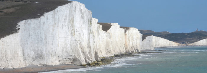
The sub-sea features point in the direction of the 21-mile-wide Dover Straits. For over a hundred years geologists have been puzzled by these narrows that connect the English Channel to the North Sea. The scenic chalk cliffs that line the straits on both the English and French sides are familiar to many. What is perhaps less obvious is that the cliffs are the interrupted edges of a once-continuous ridge that spanned the straits, called the Weald-Artois anticline.
At a time when sea level was about 100 meters lower, during the post-Flood Ice Age, this ridge apparently formed a dam that held a large lake, perhaps the size of one of the smaller Great Lakes. Breaching of the rock dam at Dover Straits instigated catastrophic drainage of the lake; peak discharges on the order of one million cubic meters per second (200 times the discharge of Niagara Falls) are demanded to explain the scours in the lowlands below. The scours resemble those caused by the Lake Missoula Flood (17 times this discharge), another Ice Age deluge. When sea level rose to present levels following the Ice Age, the scoured lowland became the English Channel and the Dover "dam breach" became the Dover Straits. The course of English history was forever changed.
The new findings add to a swelling body of evidence for Ice Age megafloods as major landform-generating agents. Evidence suggests that the Ice Age ended abruptly and catastrophically. A few regions of the world that have been shaped by Ice Age megafloods include: a major portion of Washington state, the Snake River Plain of Idaho, the Altai region of southern Siberia, the Black Sea basin, the upper Mississippi River Valley, the Hudson River Valley including New York City, Wyoming's Grand Canyon of the Yellowstone, Owens River Gorge in California, and the Great Lakes/St. Lawrence drainage basin, including Niagara Falls. Now the English Channel and Dover Straits can be added to the list. A few decades ago it would have been preposterous to appeal to such non-observable events. Mere extrapolation of the processes operant in observed historic floods cannot approximate the power of the megaflood. For example, cavitation is a rock-pulverizing process that operates only when certain thresholds of velocity and power are crossed. There is a need to break away from the kind of linear thinking that was so encouraged by Lyell and others; secular scientists are to be praised for being unafraid to do so today.
Catastrophism has finally come of age.
* William A. Hoesch, M.S. geology, is Research Assistant in Geology.
Cite this article: Hoesch, W. 2007. Megafloods in the English Channel. Acts & Facts. 36 (10): 14.