 Hot Springs National Park is located about an hour southwest of Little Rock in the folded Ouachita Mountains of central Arkansas. It is the second smallest national park in the United States at just under nine square miles. Park employees like to claim it’s the “oldest area in the parks system” because in 1832 President Andrew Jackson signed legislation designating it as a federally protected region.1 It became a national park in 1921.2
Seventy springs were counted in the original 1804 survey, but today there are 47 springs that still produce 750,000 to 950,000 gallons of thermal water a day.2 Display Springs is the only one that was left in its natural state. All others have been covered and are used to pipe water to the bathhouses and fountains within the park.2 Water temperatures run from about 95°F to above 147°F.2 Most hot springs elsewhere have a foul, sulfur-rich smell, but Hot Springs water is known for its “exceptional purity, with no unpleasant taste or odor,”3 making this hydrothermal system unique.
Park rangers claim the geologic features of the park extend back over 400 million years. But the rocks in the park don’t tell us their age, and conventional geologists struggle to understand how many of these features formed. Three observations demonstrate how Hot Springs formations are best explained by the much more recent global Flood.
- Thick layers of marine sediment called chert, or flint, blanket the area.
- Outcroppings throughout the park reveal tightly folded rock layers.
- A small stream flows through a water gap, dividing two mountains. Why did it cut across the ridge instead of going around?
Flood Rocks at Hot Springs
Rocks exposed in the park comprise two sedimentary megasequences. The lower layer is the Tippecanoe and the upper is the Kaskaskia. Each megasequence represents a major pulse or advance of ocean water onto the pre-Flood continents. This was followed by a slight drop in water level before a new megasequence advanced on top of the previous one. Megasequences are like chapters in the Flood, with individual strata for pages, and each one contains unique marine fossils. Both of these megasequences were part of the early progression of the global Flood, likely deposited prior to day 40 of the Flood year.4
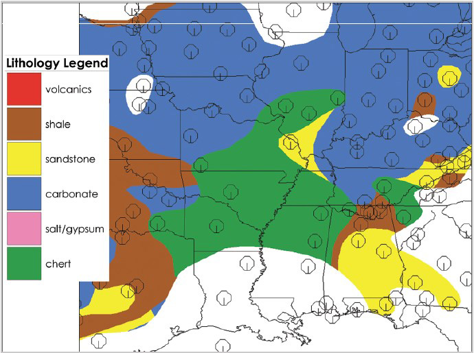
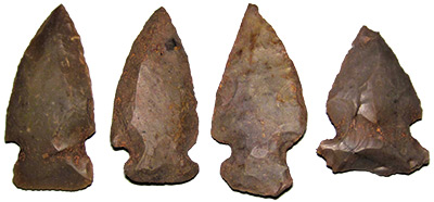
An unusual rock type formed across Arkansas during deposition of the Tippecanoe and Kaskaskia Megasequences. This rock is an ocean sediment known as chert or flint. It’s a type of fine-grained quartz that’s fairly amorphous, like agate. Many cultures used chert to make arrowheads and other stone tools. Figure 1 shows the extent of the Kaskaskia chert-rich rocks in green. Note this same deposit covers most of Arkansas and parts of the surrounding states. Conventional geologists don’t fully understand how such thick, extensive layers of chert could form.
The Tippecanoe layer, called the Bigfork Chert, is about 750 feet thick. The Kaskaskia quartz-rich rock is called novaculite, which is similar to chert but is mostly microcrystalline quartz. This layer is called the Arkansas Novaculite and is about 900 feet thick. Both rock types consist of very pure quartz. Creation geologists think chert-rich rocks formed in the Flood because of an unusual water chemistry that possibly denotes extremely hot water rich in dissolved quartz. Regardless, the thickness and extent of these deposits are best explained by the global Flood’s massive waves and megasequences.
Folding and Faulting of the Sediments
Many rock layers throughout the park are tilted and tightly folded. Conventional geologists claim they folded over 300 million years ago during the same tectonic plate collision that formed the Appalachian Mountains. Some of the layers would have been over 100 million years old at the time they were deformed and should have been solid rock by then. Rocks today do not fold—they shatter. How did these rocks fold so easily?
Flood geologists can explain this. They propose that just weeks after the sediments of the Tippecanoe and Kaskaskia Megasequences were deposited in the early Flood, a tectonic collision folded them. The Ouachita Mountains formed as two plates rammed together at a rate of yards per second,4 which was much faster than today’s plate velocities. This is known as catastrophic plate tectonics,4 and it only occurred during the Flood year. The plate collision caused the still-wet and compacted sediments to bend, fold, and even fault. This explains why the mountains in the park are so tightly deformed but not shattered.
Late Flood Erosion
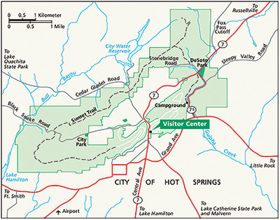
The park’s visitor center is located in a water gap (valley) between Hot Springs Mountain to the east and West Mountain to the west (Figure 2). Today, a rather small stream called Hot Springs Creek flows through this gap. Why would a waterway cut through the ridge and divide these two mountains? The water should have gone around.
Conventional scientists claim this is a product of stream piracy in which a stream on one side of the ridge just happened to originate at the same location as a stream running down the other side. Over time, one of the streams overtook the other (piracy). But the coincidence of this happening is highly unlikely.
Instead, Flood geologists suggest the uplift of the Ouachita Mountains caused fractures and faults to cut across the ridges. During the highest point of the Flood, water would have been well over the tops of these mountains. As the Flood began to recede, water would rush through these cracks, widening them until a gap was created. Today, small streams like the one at the visitor center continue to flow through these gaps.
Hot Springs Hydrothermal System
The Flood’s receding water eroded the Zuni Megasequence sediments that had likely been deposited across the park during the peak of the Flood.4 Zuni layers are found just to the south and extend underneath the Gulf of Mexico.4 The receding Flood also rounded and smoothed the ridges, created water gaps, and exposed the highly folded chert layers.
Today, rainwater enters the ground through the fractured, chert-rich layers, percolates downward possibly a mile,2 and is warmed by the earth’s geothermal gradient. Sinking rainwater recharges and pressurizes the system, forcing heated water up along faults and permeable sand layers. This produces the springs. The water is so pure because the chert source rocks don’t readily dissolve like limestone does. This also possibly explains the lack of odor since chert doesn’t contain sulfur-rich minerals.
Genesis 2 describes the pre-Flood world as having mists rising from the earth, possibly fed by springs. It also describes a river that went out of Eden that was perhaps also fed by springs. While the global Flood completely changed the earth’s surface and we can only speculate about pre-Flood conditions, perhaps the hydrothermal system at Hot Springs provides a glimpse into how the Creator might have engineered that earlier hydrologic system.
Conclusion
Hot Springs National Park showcases layers of sedimentary rock deposited and folded in the Flood about 4,500 years ago. The smoothed ridges and water gaps illustrate the power of the receding floodwaters, and the many springs demonstrate the wonders of the hydrologic cycle engineered by the Lord Jesus. These springs help provide water for us today, and similar springs might have supplied the pre-Flood world, too. They certainly give us more cause to celebrate the wonders of God’s creation.


References
- Croyder, L. 1999. Hot Springs. America’s Spectacular National Parks. D. Levy and L. B. O’Connor, eds. Los Angeles, CA: Perpetua Press, 27.
- Hacker, D. and D. Foster. 2018. Hot Springs National Park. Geology of National Parks, 7th ed. A. G. Harris et al., eds. Dubuque, IA: Kendall Hunt Publishing Company, 935–947.
- Ibid, 937.
- Clarey, T. 2020. Carved in Stone: Geological Evidence of the Worldwide Flood. Dallas, TX: Institute for Creation Research.
* Dr. Clarey is director of research at the Institute for Creation Research and earned his Ph.D. in geology from Western Michigan University