NUMERICAL SIMULATION OF PRECIPITATION INDUCED BY HOT MID-OCEAN RIDGES
by Larry Vardiman *
Institute for Creation Research Graduate School
10946 Woodside Ave. N., Santee, CA 92071
Voice: (619) 448-0900 Fax: (619) 448-3469
10946 Woodside Ave. N., Santee, CA 92071
Voice: (619) 448-0900 Fax: (619) 448-3469
Presented at the Fourth International Conference on Creationism
Pittsburgh, PA, August 3-8, 1998v Copyright 1998 by Creation Science Fellowship, Inc.
Pittsburgh, PA USA - All Rights Reserved
Pittsburgh, PA, August 3-8, 1998v Copyright 1998 by Creation Science Fellowship, Inc.
Pittsburgh, PA USA - All Rights Reserved
KEYWORDS
Community Climate Model, Climate, Climate model, Global Climate Model, Hot mid-ocean Ridges, Hypercanes, Ice-age, Mid-ocean Ridges, Precipitation, Ridges, Sea-surface Temperature
ABSTRACT
A numerical global circulation model developed at the National Center for Atmospheric Research was used to simulate the wind and precipitation patterns caused by a hot sea-surface temperature over the current mid-ocean ridge locations. In three separate simulations the surface was maintained at 30°C, 50°C, and 70°C in a pattern similar to the mid-ocean ridges. The model was run at each temperature condition for a year of real time and the wind and precipitation patterns studied.
Climate simulations for the three different mid-ocean ridge temperatures showed that increased temperatures lead to increased precipitation over and downwind of the ridge, increased horizontal wind speed in the lower atmosphere, decreased horizontal wind speed aloft, and an increase in the frequency of upward vertical velocity over the ridges. The rate of precipitation exceeded 20 mm/day over large portions of the ridges and was up to 80 mm/day in limited areas. It was greatest over Greenland and the North Atlantic south of Greenland. Precipitation also extended over portions of the ocean away from the ridges, toward polar regions, and into continental areas, particularly near the equator. Precipitation rates and the area of coverage increased globally as the ridge temperature was increased. The effects appear to match many of the expectations from the Scriptures and inferred distributions of snow and ice coverage during the "Ice Age."
INTRODUCTION
Mid-ocean ridges are significant features of the earth's crust. They form the world's largest mountain chain extending for 65,000 kilometers along the bottom of the oceans. The ridges have widths of 500 to 5000 kilometers and, in places may occupy as much as one-half of the total area of the ocean floor. Portions of this gigantic submerged mountain range rise to over 2500 meters above the nearby floor of the deep-ocean basin.
The mid-ocean ridges are composed of thick layers of basaltic rocks which have been faulted and uplifted. These ridges of basaltic rock are located along rift zones between tectonic plates and through which magma flows from the underlying asthenosphere. It is commonly believed that the basalt in the ridges has taken up to 200 million years to flow upward, spread laterally, and cool, forming the ocean floors.
However, if these features formed rapidly during and following the Genesis Flood in only a few years, as suggested by Wise et al. [6], they would have transferred a large quantity of heat to the ocean in the vicinity of the ridges, producing enhanced evaporation. It is likely that this water vapor would have contributed to the heavy rain described in Scripture during and immediately following the Flood. In some places where the ocean temperature exceeded 50°C, gigantic hurricanes such as those suggested by Emanuel [3] may have been generated in the atmosphere, lofting large quantities of moisture into the stratosphere which would have precipitated over large regions of the globe.
This paper will report on an initial simulation of precipitation and wind fields when the sea-surface temperature is maintained at higher than normal levels over the current locations of mid-ocean ridges. The Community Climate Model (CCM1) developed at the National Center for Atmospheric Research (NCAR) was adapted to run on an IBM-compatible personal computer at the Institute for Creation Research.
The model uses 1920 grid points in 4.5° latitude by 7.5° longitude intervals to characterize the pressure, temperature, wind, and moisture fields over the surface of the earth. It uses 12 pressure levels in the vertical to describe the volume of the atmosphere. CCM1 is a spectral model which uses grid values to define spherical functions and predict future values in time and space. The model is described by Williamson et al. [5], Bath et al. [1], and Bath et al. [2].
Calculations were done in 15-minute increments for one year for three ridge temperatures of 30°, 50°, and 70°C. The model required about five weeks of continuous running time to simulate one year of real time on a 100 MHz PC-486. The same model runs in about one week on a 166 MHz Pentium. Six of about 50 possible output variables were saved every ten days for each of the three runs. This report will discuss the resulting wind and precipitation fields at the end of one year of the simulations.
THE MID-OCEAN RIDGE
Fig. 1 shows the 1920 grid points used in CCM1 on the surface of the earth and the grid points held at elevated temperatures associated with the mid-ocean ridge. The small empty circles indicate the computational grid points and the darkened circles the grid points over the ridge. The location of the mid-ocean ridge was obtained from a published map by Heezen and Tharp [4]. Note that the ridge runs down the middle of the Atlantic Ocean from north of Iceland to near Antarctica. In the Southern Ocean it circles the globe south of the Cape of Good Hope and Australia. In the southern Pacific Ocean it turns northward to intersect the North American Continent near the west coast of Mexico. In the Indian Ocean it branches northward to intersect the African continent near the mouth of the Red Sea. The ridge is widest in the South Atlantic and South Pacific. Multiple grid points were used to represent the width of the ridge. In general, two grid points were used to straddle narrow regions of the ridge and four or more for wide regions. No effort was made to vary the number of grid points as a function of the height of the ridge or likely hot spots.
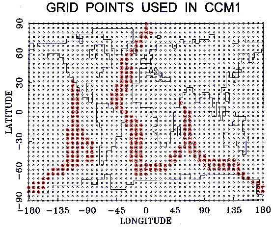
Figure 1.Grid points used in CCM1. Darkened circles are grid points over the mid-ocean ridge. Click image to enlarge
PRECIPITATION PATTERNS
Figs. 2-4 show the precipitation patterns for ridge temperatures of 30°, 50°, and 70°C. It is easy to follow the 30°C mid-ocean ridge by the precipitation patterns in Fig. 2. Most of the precipitation is in the range of 5 to 10 mm/day with only occasional areas exceeding 20 mm/day, except in the North Atlantic. Most of the precipitation falls over the ocean. The only regions where precipitation falls on the continents is along the northern and southeastern coasts of Greenland, the northern coasts of Europe and Asia, the northeast coast of South America, and the coast of Antarctica.
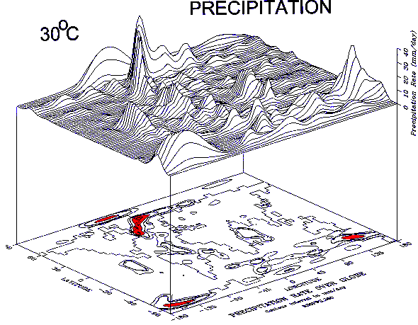
Figure 2.Precipitation rate in mm/day over the globe for grid points over the ridge of 30°. Contour intervals in the lower diagram are shown at 5, 10, 20, 40, and 80 mm/day increments. The upper diagram shows the same precipitation reate data on a 3D surface. Click image to enlarge
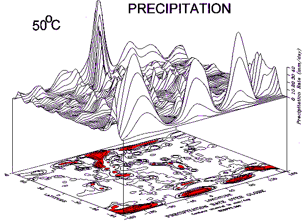
Figure 3.Precipitation rate in mm/day over the globe for grid points over the ridge of 50° Other featuers are the same as in Fig. 2. Click image to enlarge
For a 50°C ridge temperature the area of precipitation with rates above 5 mm/day approximately doubles, as shown in Fig. 3. Maximum values exceed 80 mm/day in the North Atlantic and over three concentrated regions of Antarctica. The precipitation patterns still follow the mid-ocean ridge, but the pattern is more complex with areas of precipitation extending partially into the continents. In addition to precipitation along the coasts mentioned for the 30°C ridge, the pattern now includes precipitation along the coast of northern Canada, through central Asia, across central and eastern Africa and India, along the coast of southeastern Asia, across central South America and its southern tip, and into the interior of Antarctica.
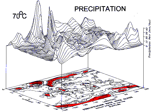
Figure 4.Precipitation rate in mm/day over the globe for grid points over the ridge of 70°. Other features are the same as in Fig. 2. Click image to enlarge
For a 70°C ridge temperature the area of precipitation with rates above 5 mm/day increases again, as shown in Fig. 4. Maximum values exceeding 80 mm/day have shrunk somewhat in size and occur only in two locations, one over Greenland and the other in the North Atlantic south of Greenland. The area in the Antarctic exceeding 80 mm/day for the 50oC ridge has disappeared. The large areas of precipitation seem to spread downwind like a plume from a source region. When we consider the wind fields in the next section, we will see this to be a good interpretation. In the North Atlantic, the high precipitation area south of Greenland extends north and eastward across the Arctic Ocean, Europe, and Asia. It even appears to continue across the Bering Sea into Alaska and Canada. A large area of precipitation forms on western Greenland as this plume rises over the cold, high elevation of Greenland. The end of this plume also produces a streamer of precipitation southeastward across the northeastern U.S. South of this northernmost plume, between approximately 30-45° north latitude, little precipitation seems to occur. A similar lack of precipitation seems to be evident from 30-45&3176 south latitude. These dry features are probably due to downward air motions in the Hadley cells which rise near the equator and descend to the north and south. If this is the case, the size of the cells is much greater than normal since the region of descent today is between 20-30° latitude in the two hemispheres. Under consistently descending regions of air few clouds form, little precipitation occurs, and deserts develop. The dry region across central Europe, the northern Mediterranean, the mid-East, and central Asia apparent in Fig. 4 would have encouraged easy migration east-west for civilizations following the Flood.
Fig. 5 shows histograms of precipitation for the three temperatures. Note the decrease in the number of grid points with precipitation less than 5 mm/day and the increase in all categories of precipitation greater than 5 mm/day as the temperature increases.
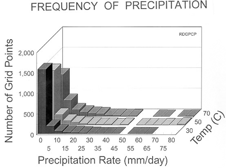
Figure 5.Frequency histograms of precipitation rate in mm/day for ridge temperatures of 30°C, 50°, and 70°C.
HORIZONTAL WIND PATTERNS
Figs. 6-9 show the horizontal wind fields at four levels (9 mb, 110 mb, 500 mb, and 811 mb) in the atmosphere after one year of computation with a 70°C ridge. These levels are characteristic of the wind at approximately 30, 15, 5, and 2 kilometers above sea level in the atmosphere, respectively. Winds computed by the model at the other eight levels are intermediate between these levels. Winds for the three different temperatures generally show similar patterns with some variation in the location and intensity of closed circulations and small-scale features.
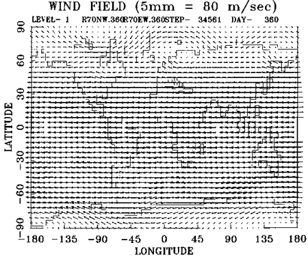
Figure 6.Horizontal wind field over the globe at a pressure of 9 mb (30 km asl)
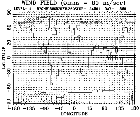
Figure 7.Horizonal wind field over the globe at a pressure of 110 mb (15 km asl)
At the highest levels in the atmosphere the winds between the equator and 60° north and south latitude are mostly from due east with the highest speeds near the equator of about 100 m/s. Poleward of 60° latitude in both hemispheres the winds are still from the east but at a much lower velocity and with large eddies. Looking at lower levels down through the atmosphere, the winds in the tropics become slower but maintain a generally smooth flow from the east between about 30° north and south latitude. Northward of 60° latitude in both hemispheres the winds become westerly, increasing in speed near the surface. Large eddies are evident in the flow in the polar regions. A region of relatively calm winds with many small eddies develops between 30° and 60° latitude in both hemispheres between the high-speed easterly flow near the equator and westerly flow near the poles. This region of low winds, called the "doldrums," becomes larger as one approaches the surface.
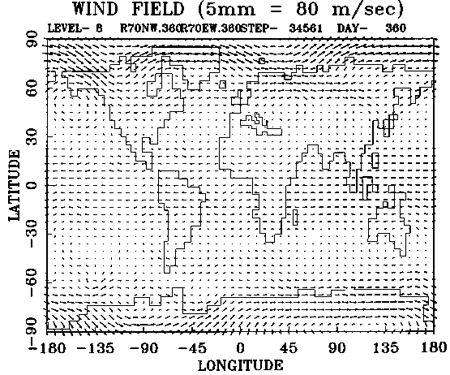
Figure 8.Horizonal wind field over the globe at a pressure of 500 mb (5km asl)
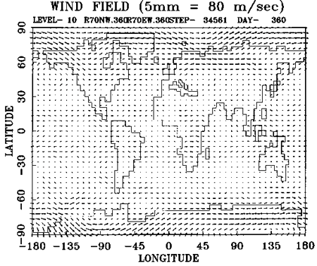
Figure 9.Horizonal wind field over the globe at a pressure of 811 mb (2 km asl)
Fig. 9 shows the winds at a level which should effectively transport heat and moisture from the ridges toward the continents. The winds at 811 mb are approximately 2 kilometers above sea level and are near cloud base today. Precipitation patterns seen in Figs. 2-4 would be expected to have some relation to these wind fields. Notice that the wind direction is in the correct direction to form a plume of precipitation downwind across the North Atlantic and northern Europe from the ridge south and east of Greenland. The winds in the tropics also appear to be forming plumes across Africa and South America downwind from the ridges in the Indian Ocean and the South Atlantic. In the southern polar region the story is not quite so clear. Because the ridge is generally parallel to the wind, it is hard to determine the direction and flow of any plumes which might be formed. Interesting variations in the wind patterns over Africa and South America seem to indicate that the ridges may be creating vertical motions. The relationship between divergence in the horizontal wind fields and vertical motions will be discussed in the next section.
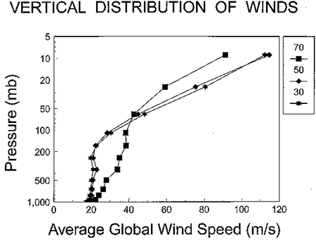
Figure 10. Average global wind speed in m/sec as a function of ridge temperature and pressure. Ridge temperature of 30°C, 50°C, and 70°C are shown as stars, diamonds, and boxes, respectively. The vertical distance is proportional to height in the atmosphere since pressure is plotted as a logarithmic function.
Fig. 10 shows the average global wind speed as a function of ridge temperature and pressure. The wind speed at pressures greater than about 200 mb (altitudes below 12 kilometers) increases and the wind speed at pressures less than 200 mb (altitudes above 12 kilometers) decreases as the ridge temperature becomes hotter. Apparently, low level heating by the mid-ocean ridge causes a change in the vertical structure of the atmosphere. To more fully understand these changes and their causes would require a full exploration of pressure, momentum, and energy balances thoughout the entire atmosphere which is beyond the scope of this paper.
VERTICAL WIND PATTERNS
Fig. 11 shows the average vertical wind speed on the earth between the surface and the level at 245 mb for a 70°C ridge temperature. The vertical wind speed is found by integrating the divergence in the horizontal wind fields upward from the earth's surface according to Eq. 1:
|
|
(1) |
where wT is the vertical velocity in pressure units at the top of a layer of air in the atmosphere, wB is the vertical velocity at the bottom of a layer, P is the pressure, and u and v are the components of the wind in the easterly and northerly directions x and y, respectively. The bottom of the layer was assumed to be at the surface of the earth and wB was assumed to be zero. The vertical wind is not zero at the surface if the horizontal wind is flowing up or down an inclined plane. However, calculations of vertical wind with no upward motions at the surface are representative of the dynamic effects of the atmosphere alone. The divergence in the horizontal wind field (the term in brackets in Eq. 1) was calculated using a 5-point computational algorithm.
The layer of air between the earth's surface and 245 mb (about 10 kilometers) is known as the troposphere. Most of the weather affecting the earth's surface occurs in the lowest 10 kilometers of the atmosphere. The calculation of the average vertical wind speed in this layer of air might be expected to relate to precipitation at the surface. Upward motion of moist air produces condensation, clouds, and precipitation while downward motion of moist or dry air results in clear skies and dry surface conditions.
In reality, no such correlation should necessarily exist. The model is a large-scale one and the fields of vertical velocity reflect the overall general circulation patterns generated by the energetics of the entire atmosphere. Thus, vertical motion features such as are associated with the meridional cells and large standing waves would dominate the vertical velocity fields. The effect of the hot ridges would be felt principally as a large-scale energy input that would modify these large scale circulation features in a general way throughout the globe. The precipitation induced by the hot ridges, however, would be produced by localized convection at the cloud scale. The resulting localized vertical motions would not be resolved by the model. This convection and associated rainfall is handled in the model by a Figure 11 Vertical velocity in mb/hr on the globe. Contour intervals on the lower diagram are shown in increments of 200 mb/hr, both positive (up) and negative (down). The upper diagram shows the same vertical velocity data on a 3D surface. parameterization scheme that takes care of processes at scales much smaller than the space resolution of the model. The resolved large scales would respond to the overall energetic effects of the clouds by modifying in a general way the large-scale features of the general circulation.
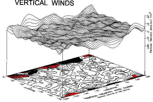
Figure 11.Vertical velocity in mb/hr over the globe. Contour intervals on the lower diagram are shown in increments of 200 mb/hr, both positive (up) and negative (down). The upper diagram shows the same vertiacal velocity data on a 3D surface. Click image to enlarge
Fig. 11 shows that upward air motions occur in the North Atlantic, the South Pacific, and the Southern Oceans where the mid-ocean ridge is located. The upward motions exceed 500 mb/hr northeast of Iceland and are generally upward over the entire North Atlantic. Upward motions in the South Pacific and Southern Oceans seldom exceed 100 mb/hr and are more difficult to associate with the ridge. Along other portions of the ridge, the upward motions are even more chaotic, and if there are associated patterns, they are displaced away from the ridge. In a few locations there appears to be a good correlation between upward vertical motion and precipitation, but in most locations, there is little or no correlation. It is clear that precipitation depends only partially on vertical wind fields derived from the divergence of the horizontal wind. In fact, there appears to be a general upward motion over the continents and a general downward motion over the oceans which masks the effect of the ridge.
Away from the mid-ocean ridge the strongest upward motions are associated with large waves in the westerly flow of air in the polar regions. Two centers of strong upward motion occur in the north polar region over Alaska and down along the west coast of North America and over Greenland and the North Sea into northwestern Europe. Strong downward motion occurs over Canada and eastern North America and over most of northern Asia. In the southern polar region strong upward motion occurs near the Ross Sea and downward motions elsewhere over Antarctica. Moderate upward motions occur over most of Africa, across southern Asia, and over Indonesia. It is not clear why the vertical winds in the Tropics occur in the patterns they do.
CONCLUSIONS AND RECOMMENDATIONS
Climate simulations for the three different mid-ocean ridge temperatures show that increased temperatures lead to increased precipitation over and downwind of the ridge, increased horizontal wind speed in the lower atmosphere, decreased horizontal wind speed aloft, and an increase in the frequency of upward vertical velocity over the ridges. The rate of precipitation exceeds 20 mm/day over large portions of the ridge and is up to 80 mm/day in limited areas for a 70°C ridge. It is greatest over Greenland and the North Atlantic south of Greenland. Precipitation also extends downwind over portions of the ocean away from the ridge, toward polar regions, and into continental areas, particularly near the equator. Precipitation rates and areas of coverage increase globally as the ridge temperature are increased.
The horizontal winds from the surface through the troposphere are westerly from mid-latitudes poleward in both hemispheres and easterly at equatorial latitudes. Between 30-45° north and south latitudes the winds are relatively calm in what are called the doldrums. The heat and moisture over hot ridges cause the frequency of downward motions to decrease and upward motions to increase. Precipitation in the doldrums falls over the mid-ocean ridge where it forms. However, increased precipitation over the mid-ocean ridge in equatorial latitudes drifts westward and precipitation in polar latitudes drifts eastward to fall on continental regions.
It is apparent that hot mid-ocean ridges cause a large change in the distribution of winds and precipitation globally. The effects are not limited to only locations near the ridge. Average global horizontal wind speeds in the lower atmosphere are increased as the ridge temperature is increased. Precipitation rates and coverage increase, particularly toward the polar regions as the ridge temperature is increased. Some of the precipitation patterns seem to match those which occurred during the "Ice Age."
These effects appear to be consistent with many of the expectations from the Scriptures and inferred distributions of snow and ice coverage during the "Ice Age." If the Genesis Flood was a global, catastrophic event as described in the Scriptures, it would have been accompanied by large crustal movements, formation of mid-ocean ridges, and significant heating of the ocean in locations near the ridges. This heating would have produced increased evaporation over the oceans and precipitation over the continents and polar regions. The model simulations have shown that the distribution of precipitation in the polar regions follows the distribution of snow and ice which occurred during the "Ice Age." This match increases confidence in the catastrophic, tectonic Flood model of Wise et al. [6]. CCM1 simulates the global dynamic and hydrological effects caused by a change in sea-surface temperature like those suggested in this paper. However, it can not simulate smaller-scale features and even hotter temperatures which might have been generated during the actual Flood event. The formation of "hypercanes" as suggested by Emanuel [3] would probably occur under the conditions assumed in this research and could be an additional factor on precipitation and wind.
Future research on hot mid-ocean ridges should focus on three areas. First, a complete study of the changes in the global distributions of energy and momentum would help to understand how and why the wind fields are affected by heat and moisture released by the ridge. Second, mesoscale "hypercane" models should be incorporated into the study of winds and precipitation. And, third, precipitation patterns associated with hot mid-ocean ridges should be more carefully compared with those which occurred during the "Ice Age" to see if even finer details can be distinguished. Some of the precipitation may have fallen as heavy rain in the equatorial and mid-latitude regions producing distinctive erosional features rather than ice and snow coverage.
ACKNOWLEDGMENTS
Calculations for this study were made on computers provided by Steve Low and his associates at the Hewlett-Packard Corporation. The basic code for CCM1 was provided by James Hack at the National Center for Atmospheric Research. It was modified to run on an IBM compatible personal computer by Herman Daily. Karen Bouselot prepared several of the graphical products used for displaying wind and precipitation distributions. Numerous donors to the Institute for Creation Research financially supported this effort. Appreciation is expressed to one of the reviewers for his contribution on the interaction between cloud-scale and general circulation dynamics. Elohim is praised for the beauty and design inherent in His creation of the atmosphere. I can only marvel at the intricacy of this system and how little we know about how it works.
REFERENCES
- Bath, L.M., M.A. Dias, D.L. Williamson, G.S. Williamson, and R.J. Wolski, User's Guide to NCAR CCM1, NCAR Technical Report, TN-286+IA, 1987, National Center for Atmospheric Research, Boulder, Colorado.
- Bath, L.M., M.A. Dias, D.L. Williamson, G.S. Williamson, and R.J. Wolski, Documentation of NCAR CCM1, NCAR Technical Report, TN-287+IA, 1991, National Center for Atmospheric Research, Boulder, Colorado.
- Emanuel, K.A., K. Speer, R. Rotunno, R. Srivastava, and M. Molina, Hypercanes: A Possible Link in Global Extinction Scenarios. Journal of Geophysical Research, Vol. 100, No. D7, (1995)13,755-13,765.
- Heezen, B. and M. Tharp, World Ocean Floor. A map of 1 sheet, 1977, Lamont-Doherty Geological Observatory, Palisades, NY and U.S. Navy, Office of Naval Research.
- Williamson, D.L., J.T. Kiehl, V. Ramanathan, R.E. Dickinson, and J.J. Hack, Description of NCAR Community Climate Model (CCM1). NCAR Technical Report, TN-285+STR, 1987, National Center for Atmospheric Research, Boulder, Colorado.
- Wise, K.P., S.A. Austin, J.R. Baumgardner, D.R. Humphreys, A.A. Snelling, and L. Vardiman, Catastrophic Plate Tectonics: A Global Model of Earth History, Proceedings of the Third International Conference on Creationism, R.E. Walsh, et al., Editors, 1994, Creation Science Fellowship, Inc., Pittsburgh, PA, pp. 609-622.